26 Astro 320 and DC40 Owner’s Manual
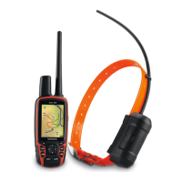
Waypoints, Routes, and Tracks
1. From the main menu, select Setup
> Tracks > Track Log.
2. Select Record, Do Not Show or
Record, Show On Map.
If you select Record, Show On
Map, a line on the map indicates
your track.
3. Select Record Method.
4. Select an option:
• Select Distance, and enter a
distance interval.
• Select Time, and enter a time
interval.
• Select Auto to specify the
interval of frequency.
NOTE: Using the Most Often
interval provides the most track
detail, but lls up the device
memory quicker.
As you move with the device turned
on, a track log is created.
1. From the main menu, select Tools >
Track Manager.
2. Select a track.
3. Select View Map.
1. From the main menu, select Tools >
Track Manager.
2. Select a track.
3. Select Elevation Plot.
4. Complete an action:
• Press left or right on the Rocker
to scroll across the track.
While scrolling, press ENTER
to show the point on the map.
• Press up or down on the Rocker
to set the zoom range.