Do you have a question about the Garmin eTrex 30 and is the answer not in the manual?
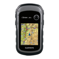
Details the physical layout, buttons, and screen elements of the eTrex device.
Covers battery types, installation, and tips for maximizing battery life.
Guides users through powering on the device, acquiring satellites, and registration.
Explains how to create, manage, and use waypoints, routes, and track logs.
Details navigating to destinations using maps, including browsing and route display.
Covers using the compass for navigation and viewing elevation plots and trip data.
Guides on downloading, filtering, navigating, and logging geocaches.
Explains features like data sharing, alarms, calculator, and calendar functions.
Covers personalization of menus, displays, tones, profiles, and system settings.
Details map display, track recording, routing preferences, and units of measure.
Explains configuration for time, position, heading, and altimeter parameters.
Covers viewing device details, software updates, and connecting to a computer.
Explains file management, installing microSD cards, and transferring data.
Includes optional accessories, data field explanations, and problem-solving solutions.
| Outdoor (hiking, trekking) | Yes |
|---|---|
| Marine (chartplotters, sounders) | No |
| Routes quantity | 200 |
| Number of waypoints | 2000 |
| Form factor | Handheld |
| Display diagonal | 2.2 \ |
| Display resolution | 176 x 220 pixels |
| Display number of colors | 65536 colors |
| Display size (HxV) (imperial) | 1.7 x 1.4 \ |
| Internal memory | 1740 MB |
| USB 2.0 ports quantity | 1 |
| Battery type | AA |
| Battery life (max) | 25 h |
| Battery technology | Nickel-Metal Hydride (NiMH) |
| Number of batteries supported | 2 |
| Depth | 33 mm |
|---|---|
| Width | 54 mm |
| Height | 103 mm |
| Weight | 141.7 g |
