Do you have a question about the Garmin G1000:Piper and is the answer not in the manual?
Discusses the controls located on the PFD and MFD bezels and audio panel for system operation.
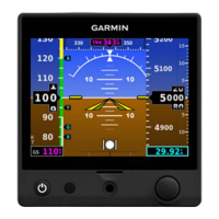
Details the flight instruments and supplemental flight data displayed on the Primary Flight Display (PFD).
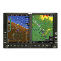
Describes critical engine, fuel, electrical, and cabin temperature indicators on the MFD.
Details COM transceiver selection, activation, tuning, and auto-tuning.
Covers NAV radio selection, activation, manual tuning, and auto-tuning.
Describes the MFD Navigation Map Page setup and operations.
Details the 'direct-to' navigation feature for setting GPS course to a destination waypoint.
Describes G1000 capabilities for flight plans, airways, and vertical navigation.
Explains loading and activating departure, arrival, and approach procedures.
Covers XM Satellite Weather data, activation, products, and display on G1000.
Details Stormscope system, display options, and operation with loss of heading input.
Explains Terrain Proximity system, requirements, limitations, and display data.
Covers Traffic Information Service (TIS) and Traffic Advisory System (TAS) operation and symbology.
Describes SafeTaxi feature for detailed airport taxiway and runway information.
| Type | Integrated Avionics System |
|---|---|
| Manufacturer | Garmin |
| Display Type | LCD |
| Storage Temperature | -40°C to +70°C |
| Primary Flight Display (PFD) | Yes |
| Multi-Function Display (MFD) | Yes |
| Suitable Aircraft | Piper aircraft |
| Resolution | 1024 x 768 pixels |
| Weight | Varies by configuration |
| Interfaces | ARINC 429, RS-232, Ethernet |
| Certification | FAA TSO |
| AHRS | Yes |
| Air Data Computer (ADC) | Yes |
| GPS | Yes |
| Transponder Control | Yes |
| Engine Monitoring | Yes |