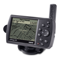
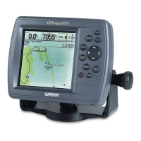
GPSMAP
®
176 and 176C
Since space is at a premium on most
boats, we maximized the display on this
chartplotter while keeping overall size
slim and compact. Whether you choose
the bright, 16-color transflective screen
of the GPSMAP
®
176C or the 12-level
grayscale display of the GPSMAP 176,
you’ll get a clear picture of where you
are on the map. Both units offer excellent
built-in maps, and they accept data from
preprogrammed data cards or MapSource
™
CD-ROMs with BlueChart
™
marine
cartography. Additional cartography
includes offshore marine detail, navaids,
street addresses, restaurants, services and
more. And they are portable, so they
easily go from your boat to your vehicle.
Portable chartplotter in color or monochrome display