Do you have a question about the Garmin GPSMAP 178C and is the answer not in the manual?
Manual overview, product registration, and software license terms.
Details FCC compliance for Class B digital devices.
Provides important warnings and cautions for product use.
Information on product warranty and serial number recording.
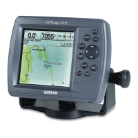
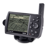
Lists the key features and capabilities of the GPSMAP 178C.
Lists items included in the standard package and optional accessories.
Explains keypad usage, data entry, and powering on/off.
Covers tours, simulator, main pages, map cursor, waypoints, and NAV key.
Details Map/Sonar split, Sonar page, Compass, and Highway pages.
Covers data fields, active route, main menu, and waypoint deletion.
Overview, cursor, zooming, and page options.
Combines Map and Sonar pages with adjustable split window.
Overview, adjustment menu, and tab options.
Steering guidance using compass and highway displays.
Creating, using, editing, and listing waypoints.
Creating, following, and editing routes.
Retracing paths and Man OverBoard function.
Searching for waypoints, map items, and other data.
Overview of menu tabs for system, navigation, and setup.
Satellite acquisition, status, accuracy, and WAAS capability.
Tide charts, celestial data, and track log management.
Digital Selective Calling features and communication setup.
Configuring system, navigation, and sonar alarms.
Antenna, unit, and transducer mounting instructions.
Connecting cables, interfacing, and managing data cards.
Guidance on cleaning, storage, and handling water immersion.
Explanation of the Loran TD feature and setup.
Lists various map datums and their usage.
Explains on-screen messages for unit status and alerts.
Definitions of common navigation terms used in the manual.
Chart of approximate UTC time offsets for longitudinal zones.
Explains how sonar displays underwater objects and returns.
Details the area covered by different transducer cone angles.
How whiteline and thermoclines indicate bottom type and fish location.
Lists the unit's dimensions, weight, display, and performance metrics.
Guidance on cleaning, storage, and handling water immersion.
| Display Resolution | 320 x 240 pixels |
|---|---|
| Display Type | Color TFT |
| Weight | 1.5 lbs |
| Waterproof Rating | IPX7 |
| Routes | 50 |
| Track Log | Up to 10, 000 points |
| Audible Alarms | Yes |
| Accepts Data Cards | Yes |
| Sonar Capability | Yes |
| Receiver | 12-channel |
| Map Data | Preloaded BlueChart cartography for U.S. coastal areas |