Do you have a question about the Garmin GPSMAP 580 and is the answer not in the manual?
Describes the organization and content of the owner's manual.
Provides contact information for product support and inquiries.
Instructions for performing a reset on the GPSMAP 580/585 unit.
Guidelines for cleaning the exterior casing of the unit.
Details the unit's waterproof rating and immersion guidelines.
Crucial safety precautions for navigating and installing the device.
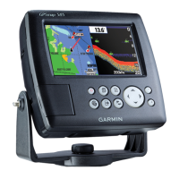
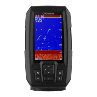
Identifies and describes the physical components of the GPSMAP 580/585.
Step-by-step instructions for powering the unit on and off.
Explains the process of obtaining a GPS fix and satellite signals.
Details the function and operation of each physical button on the unit.
Guide on how to operate the unit in simulation mode for practice.
Procedures for setting a destination and initiating navigation.
Instructions for creating, editing, and navigating routes.
Methods for creating, marking, and managing waypoints.
Guide to recording, saving, and managing track logs.
Details on using the map display for navigation and information.
Customizing the appearance of pages and data fields.
Using the compass page for steering guidance and heading.
Provides digital and graphic steering guidance to the destination.
Overview of the different tabs available in the main menu.
View satellite acquisition status, receiver status, and accuracy.
Setup and control for Digital Selective Calling features.
Defines and configures various alarm settings for the unit.
Adjust screen features like backlight, color mode, and page sequence.
Access system settings like mode, speed filter, language, and WAAS.
Overview of the sonar display, its features, and adjustments.
Detailed adjustments for sonar display parameters like range and gain.
Procedure to calibrate the water speed sensor for accurate readings.
Technical details and physical specifications of the GPSMAP 580/585.
Step-by-step instructions for installing the unit's wiring harness.
Explanation of satellite signal reception, location, and strength.
Brief descriptions of various data field options available.
| Display Resolution | 480 x 640 pixels |
|---|---|
| Receiver | High-sensitivity GPS |
| Sonar Capability | Yes |
| GPS | Yes |
| Water Resistance | IPX7 |
| Bluetooth | No |
| Wi-Fi | No |
| Display Size | 5 inches |
| Waterproof | Yes |
| Sounder Frequencies | 50/200 kHz |
| Transmit Power | 500 W (RMS) |