Resetting the Trip Info
For accurate information, you should reset the trip info before
beginning a trip.
1
Select Trip Info > Reset.
2
Select an option:
• To clear trip information such as times, distance, and
speeds, select Reset Trip.
• To clear trip information and reset the odometer, select
Reset All.
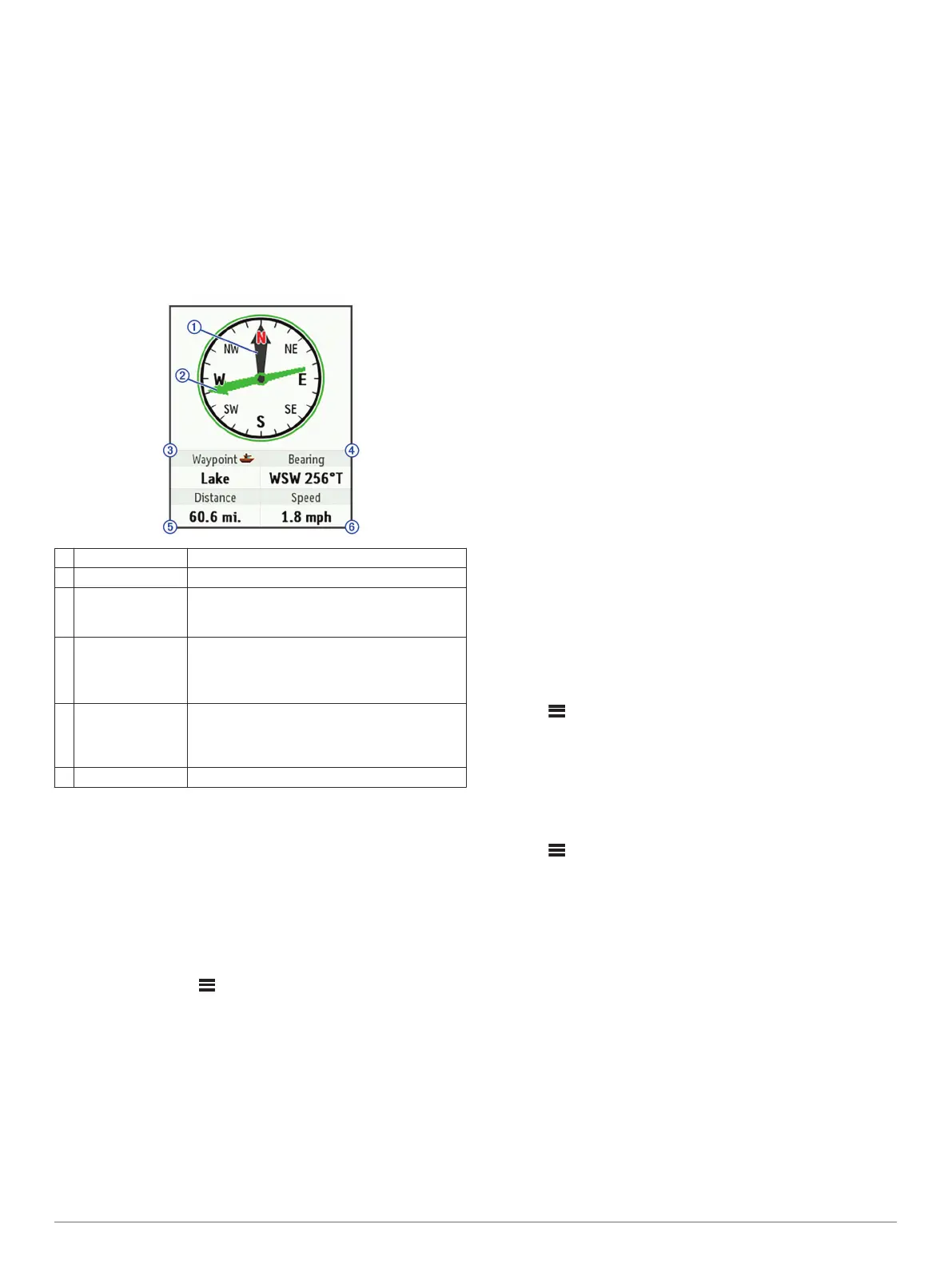
Compass
The compass features and appearance change depending on
whether you are tracking or navigating to a destination.
À
Heading pointer Indicates your directional heading.
Á
Bearing pointer Points in the direction of your destination.
Â
Elevation or
destination
Indicates your elevation.
When navigating, indicates your destination
name.
Ã
Course, bearing,
or heading
Indicates your course when you are moving.
When navigating, indicates your bearing.
On inReach Explorer+ devices, indicates your
heading when you are not moving.
Ä
Distance When tracking, indicates the distance traveled
since you started tracking.
When navigating, indicates the distance to your
destination.
Å
Speed Indicates your speed.
Navigating with the Compass
1
Begin navigating to a destination.
NOTE: When you begin navigating, your friends and family
can follow your progress and view your destination on your
MapShare web page.
2
Select Compass.
3
Turn until the heading pointer aligns with the bearing pointer,
and continue moving in that direction to the destination.
Stopping Navigation
Select Compass > > Stop Navigating.
Location
You can view your current GPS location, speed, course,
elevation, and accuracy. You can also send a message with
your location details from the location page.
Viewing and Sharing Your Current Location
1
Select Location to view your GPS location details.
2
If necessary, select Share Location to send a message with
your location details.
Weather
Your inReach device can send a message to request basic,
premium, or marine weather forecasts. You can receive weather
forecasts for your current location, a waypoint, or GPS
coordinates. Weather forecasts incur data usage charges. For
more information, go to inreach.garmin.com.
Adding a Weather Location
1
Select Weather > New Location.
2
Select an option:
• Select Use My Location.
• Select Manually Enter Coordinates.
• Select Select a Waypoint.
Requesting a Weather Forecast
1
Select Weather.
2
Select a location.
3
If necessary, select Weather > Forecast Type, and select a
Basic or Premium weather forecast.
4
If necessary, select Marine > Marine > Enabled to get a
marine weather forecast.
NOTE: For best results, you should request a marine
forecast for a location away from shore and over a large body
of water.
5
Select Get Forecast.
Updating a Weather Forecast
1
Select a location with an outdated weather forecast.
2
If necessary, change the type of weather forecast.
3
Select Update.
Editing a Weather Location
1
Select Weather.
2
Select a weather location.
3
Select .
4
Select an item to edit, such as the name.
5
Enter the new information.
Deleting a Weather Location
1
Select Weather.
2
Select a weather location.
3
Select > Delete.
Data Use and History
Viewing Data Use
You can view your plan details, and the number of messages,
preset messages, and track points sent during the current billing
cycle. The data use counter resets automatically at the
beginning of each billing cycle.
Select Data Use.
Resetting the Data Use Counter
If you are an enterprise customer, you can reset the data use
counter to monitor your usage.
Select Data Use > Reset Counter.
Viewing Data History
You can view the history of messages and track points sent by
your device.
1
Select History.
Weather 5