Do you have a question about the Garmin StreetPilot III and is the answer not in the manual?
Expresses gratitude for choosing the Garmin StreetPilot III and its auto-routing feature.
Guides the user on how to read the manual and its structure for understanding features.
Details compliance with FCC interference limits for Class B digital devices.
Provides critical safety warnings for vehicle installation and operation.
Outlines the terms and conditions for using the embedded software.
Details the product warranty, coverage, and how to obtain service.
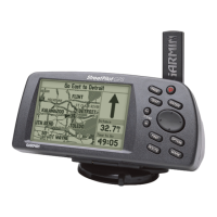
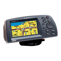
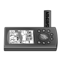
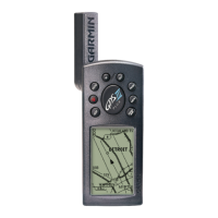
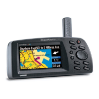
Identifies and describes the various components and connectors of the StreetPilot III.
Explains the function of each button and the rocker keypad for navigation and input.
Provides instructions and safety warnings for installing AA batteries.
Describes common features like cursor, field, and data entry procedures.
Gives an overview of the main display pages: Map, Trip Information, and Current Route.
Explains the main operating page showing map details, current location, and route.
Details navigation data displayed on the Map page like speed, distance, and direction.
Describes how to adjust map scale and navigate the map display.
Explains how to select a map feature and set it as a destination for routing.
Details options to customize the Map page display and features.
Covers settings for map detail, orientation, color mode, and auto-zoom.
Describes the display showing detailed information about the next turn in the route.
Shows the sequence of upcoming turns, directions, distance, and time for the current route.
Provides statistics about the trip, including speed, odometer, and time.
Explains how to save specific locations as waypoints for later recall.
Details the process of marking the current GPS location as a waypoint.
Introduces the menu for searching waypoints, cities, exits, and points of interest.
Explains how to search for items using names or by proximity to the current location.
Describes how to locate previously saved waypoints.
Guides on searching for and viewing information about cities.
Explains how to locate nearby highway exits and associated services.
Details how to search for points of interest like restaurants or attractions.
Explains how to find specific addresses or street intersections.
Lists recently accessed locations for quick recall.
Covers managing routes: starting, saving, recalculating, and detouring.
Provides instructions on how to manage saved routes.
Describes how to access and navigate the main menu for system settings.
Displays visual reference of GPS receiver status, satellite coverage, and accuracy.
Explains how to interpret satellite visibility and signal quality indicators.
Details the different receiver status conditions like 'Searching Sky' and '2D Navigation'.
Offers options when satellite reception is insufficient for a position fix.
Indicates the accuracy of the position fix and refers to performance specifications.
Details how to customize the GPS Information page display settings.
Shows version and map names for installed MapSource CD-ROM data.
Displays the unit's software version and unique ID number.
Provides access to various system setup functions via file tabs.
Guides on customizing system features by selecting file tabs and options.
Covers general settings like GPS mode, units, voice, and battery type.
Configures off-route recalculation and the 'Next Turn' page display.
Customizes routing preferences, calculation methods, and avoidance settings.
Allows selection of time format, time zone, and daylight savings settings.
Manages the 'Safe Mode' feature to disable certain functions while driving.
Controls recording, viewing, and clearing of the track log history.
Enables changing on-screen text and voice prompt languages.
Sets input/output formats for data exchange and GPS corrections.
Provides instructions and safety warnings for mounting the unit in a vehicle.
Describes the design and fitting of the non-skid friction mount base.
Details the steps for attaching the mounting bracket to the base.
Explains how to adjust the tilt and rotation of the mounting bracket.
Provides instructions for detaching the bracket assembly from the base.
Explains how to connect the StreetPilot III to PCs, beacon receivers, and other devices.
Lists and describes optional accessories to enhance the unit's functionality.
Covers cleaning, storage recommendations, and water immersion guidelines.
Explains how to select time zones and manually enter UTC time offsets.
Details how the StreetPilot III supports diacritical marks for European languages.
Explains MapSource City Navigator and how to transfer map data to data cards.
Lists and explains various on-screen messages and their meanings.
Provides physical and performance specifications for the StreetPilot III.
An alphabetical listing of topics and their corresponding page numbers.
| Receiver | Differential-ready 12 parallel channel GPS receiver |
|---|---|
| Warm Acquisition Time | Approximately 15 seconds |
| Cold Acquisition Time | Approximately 45 seconds |
| AutoLocate[™] Acquisition Time | Approximately 5 minutes |
| Update Rate | 1/second, continuous |
| GPS Accuracy (Position) | <15 meters, 95% typical |
| GPS Accuracy (Velocity) | 0.05 meter/sec steady state |
| DGPS (USCG) Accuracy (Position) | 3-5 meters, 95% typical |
| DGPS (USCG) Accuracy (Velocity) | 0.05 meter/sec steady state |
| Dynamics | 6g's |
| Size | 3.2"H x 6.8"W x 2.6"D (8.0 x 17.3 x 6.5 cm) |
|---|---|
| Weight | 1.4 pounds (635 g) |
| Display Size | 3.4"W x 1.8"H (8.6 x 4.5 cm) |
| Display Resolution | 305 x 160 pixels |
| Case | Rugged; fully gasketed |
| Temperature Range | 5°F to 158°F (–15°C to 70°C) |
| Power Source | 6 AA batteries or 12-volt adapter cable |
|---|---|
| Battery Life | 2–20 hours based on backlight setting |