PLANEBOOK
TM
OWNER’S MANUAL
© Gulfstream 2008 29 PlaneBook™ Owner’s Manual
7. GPS SETUP GUIDE FOR JEPPVIEW
FLITEDECK 3
TM
Introduction
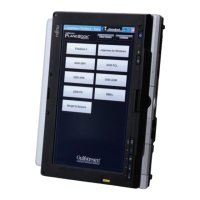
One of the special features of PlaneBook™ is its ability
to function as a moving map. This is accomplished
through the use of a GPS signal receiver working in
concert with Jeppesen’s JeppView FliteDeck 3™
software. The GPS receiver is either connected to
PlaneBook™ using a USB cable, or transmits the
position signal wirelessly using Bluetooth™ wireless
technology. With the FliteDeck 3™ software installed,
the GPS signal will overlay a dynamic aircraft symbol
on the navigational charts (or airport diagram), and also
provide three-dimensional position information on
selected displays.
Note: For more information on the use and
configurations of JeppView FliteDeck 3™ software,
please refer to the documentation accompanying the
software.
Note: Per FAA Advisory Circular (AC) 91-78, any
precomposed information being used for navigation
must be current, up-to-date, and valid. In addition, use
of this system is allowed provided this system does not
replace any navigation system or equipment required
by 14 CFR part 91.
Enabling the GPS/moving map feature is divided into
two setup procedures. The purpose of this guide is to
provide these procedures:
• PlaneBook™ Recognition of the GPS Unit and
Bluetooth™ Setup
• JeppView FliteDeck 3™ Recognition of the GPS
Signal
 Loading...