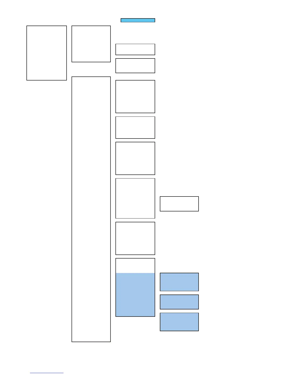
付図19 レーダーメニュー階層
Fig.19 Over View of RADAR Menu
With PLOTTER Unit (option)
MAIN MENU(RADAR MENU key)
1 RADAR Trails Setting
-
1 Trails Mode → Section 3.8.2
2 Trails Reference Level → Section 3.8.2
3 Trails Reduction → Section 3.8.2
5 Trails Process → Section 3.8.2
6 Max Interval → Section 3.8.2
7 Trails Erase
-
1 Trails Erase Mode → Section 3.4.9
2 Trails Erase Start → Section 3.4.9
3 Eraser Size → Section 3.4.9
8 File Operations
-
1 Select Card Slot → Section 3.4.10
2 Load → Section 3.4.10
3 Save → Section 3.4.10
4 Erase → Section 3.4.10
2 Map Setting
-
1 Fill Land Area → Section 3.12.4
2 C-MAP Setting
-
1 LAT/LON Line Display → Section 3.12.6
2 Depth Display → Section 3.12.6
3 Depth Unit → Section 3.12.6
4 Light Sectors Display → Section 3.12.6
5 Light Sectors Level → Section 3.12.6
6 Chart Boundary → Section 3.12.6
7 Buoy&Beacon → Section 3.12.6
8 Names → Section 3.12.6
9 Next
↓
1 Land Marks → Section 3.12.6
2 River&Lake → Section 3.12.6
3 Cultual → Section 3.12.6
4 Bottom Type → Section 3.12.6
5 Under Water → Section 3.12.6
6 Depth Contour → Section 3.12.6
3 JRC/ERC Setting
-
1 Day/Night → Section 3.12.5
2 Color of Land → Section 3.12.5
3 Bright of Land → Section 3.12.5
4 Color of Sea → Section 3.12.5
5 Bright of Sea → Section 3.12.5
6 Color of Name → Section 3.12.5
7 Bright of Name → Section 3.12.5
8 Bright of Track/Mark/Line → Section 3.12.5
9 Next
↓
1 LAT/LON Line → Section 3.12.5
2 Color of L/L Line → Section 3.12.5
3 Bright of L/L Line → Section 3.12.5
4 ERC Display Request → Section 3.12.5
5 ERC Mark → Section 3.12.5
6 JRC ROM Card Display
-
1 Lighthouse → Section 3.12.5
2 Buoy → Section 3.12.5
3 Rough Line → Section 3.12.5
4 Other Line → Section 3.12.5
7 Copy JRC ROM Card to CF → Section 3.12.3
8 Fishing Area Display
4 Contour Setting
-
1 10m → Section 3.12.5
2 20m → Section 3.12.5
3 30m → Section 3.12.5
4 40m → Section 3.12.5
5 50m → Section 3.12.5
6 60m → Section 3.12.5
7 70m → Section 3.12.5
8 80m → Section 3.12.5
9 Other → Section 3.12.5
5 Map Display Setting
-
1 Shift Coast Line 1 → Section 3.12.7
2 Shift Coast Line 2 → Section 3.12.7
3 LAT/LON Correction → Section 3.12.7
4 Map Center Position → Section 3.12.7
5 LORAN C Correction
-
1 Chain
2 TD1
3 TD2
4 TD1 Correction
5 TD2 Correction
6 LORAN A Correction
-
1 LOP1
2 LOP2
3 TD1 Correction
4 TD2 Correction
7 DECCA Correction
-
1 Chain
2 LOP1
3 LOP2
4 LOP1 Correction
5 LOP2 Correction
6 SEL JRC ROM Card File → Section 3.12.3
7 Map Draw AZI Mode → Section 3.12.8
8 JRC Card Draw Mode → Section 3.12.5
 Loading...