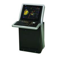
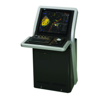
1.Overview > 1.1 Functions
1-2
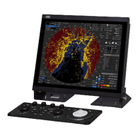
1.1.2 Main Functions of the ECDIS mode
• The following databases can be displayed.
- S-57 Ed3.0/3.1
- S-63
- C-Map Ed3.0 Professional/Professional+
- C-Map ENC
- Jeppesen PRIMAR ECDIS Service
- ARCS
• Own ship’s track display and planned-route display on the electronic chart
• Automatic checking of the safety contours and dangerous areas of the own ship (not available for ARCS)
• TT target display and AIS target display on the electronic chart
• Overlay of radar echo on the electronic chart (when ECDIS is used with the optional radar interface board)
• True/Relative motion display
• North-up/Course-up/Head-up/Waypoint-up
• Display of route information such as latitude/longitude at destinations, bearings/ranges up to waypoints,
and planned arrival time
• Availability of two EBLs/VRMs
• Writing of memos with alphabetic characters into the electronic chart
• Display of information such as the date/time, current position, heading, and ship’s speed
• Selection of colors (conforming to the IMO/IHO) suitable for the daytime, nighttime, dawn and evening
• Editing of route information
Addition, deletion, and modification of WPTs on the electronic chart or the list
Calculation of the distance between WPTs, bearings, and planned arrival time
Up to 512 WPTs per route
Checking on the crossing of the safety contours and dangerous areas on created routes
• Route tracking (option)
• Course change
• Safety contours crossing alarm
• Dangerous areas approaching warning
• Waypoint arrival warning
• Off-track warning
• Logging of navigation information onto the SSD
• Own ship’s playback using logged data
 Loading...