Do you have a question about the JRC JMR-7230-S and is the answer not in the manual?
Details acquiring, tracking, and managing targets using radar's target tracking functions.
Explains enabling, activating, and managing AIS targets, including displaying AIS information on the radar.
Guides users on how to save a planned route, including overwriting existing files or naming new ones.
Describes creating routes using a table interface for entering waypoints and route data.
Explains creating routes graphically on the chart by adding and manipulating waypoints and legs.
Covers setting up circular or polygonal monitoring areas to detect anchor dragging and generate alerts for safe voyages.
Details the final steps to engage automatic sailing, including confirming safety checks and inputting ship parameters.
Covers creating and editing user charts using menus and map creation tools.
Details creating objects like symbols, lines, areas, and text on charts during manual updates.
Customizes screen display options for own ship symbols, tracks, and graphical indications.
| Operating Temperature | -15°C to +55°C |
|---|---|
| Frequency | 9410 MHz ± 30 MHz |
| Antenna Rotation Speed | 24 rpm and 48 rpm |
| Power Supply | 100-115/220-230 VAC, 1 phase, 50/60 Hz |
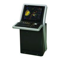
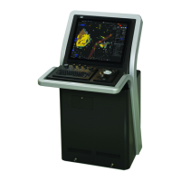
| Type | Solid-state Doppler Radar |