Do you have a question about the JRC JMR-9230-S3 and is the answer not in the manual?
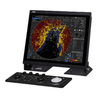
Covers fundamental operations and settings for using the radar effectively in various conditions.
Details necessary steps and settings before starting target tracking and AIS operations.
Covers the procedures for acquiring, tracking, and managing targets on the radar.
Explains how to enable, activate, and manage AIS targets for enhanced situational awareness.
Details the types of alerts generated by the target tracking and AIS systems and their conditions.
Addresses the causes and handling of unwanted echoes from sea surface and precipitation on the radar display.
Covers the process of saving a created or edited route file to the system.
Guides users through creating routes using a table-based input method.
Details the process of creating routes graphically on the chart using waypoints and legs.
Covers the methods for checking the safety and compliance of a planned route against standards and limits.
Explains the function for monitoring the ship's progress along a planned route.
Describes how to define a circular or polygonal area around the ship for anchor monitoring.
Illustrates the step-by-step process for initiating automatic sailing.
Details how to select an existing planned route or create a new one for automatic sailing.
Covers the final steps and considerations for starting the automatic sailing function.
Provides instructions on how to safely stop the automatic sailing operation.
Outlines the procedures for creating new user charts and editing existing ones.
Details the tools and functions available for creating and editing user charts and maps.
Describes how to create various objects (symbols, lines, areas, text) on charts during manual updates.
Explains how to access and view recorded navigation events and system information in the logbook.
Guides users on customizing various screen display options for optimal viewing.
Guides users on selecting alert categories and accessing their specific setting dialogs.
Covers setting conditions for collision avoidance alerts, including CPA/TCPA limits.
Details how to set conditions for new target warning alarms, including acquisition zones (AZ).
Explains how to set conditions for grounding avoidance alerts based on depth and safety contours.
Covers setting up danger detection vectors/sectors for forward forecast monitoring.
Describes setting up areas for generating alerts when danger detection vectors interact with special conditions.
Details setting conditions for checking position integrity and HDOP limits.
Explains how to configure alert actions, timeouts, and transfers to BNWAS.
Provides an overview of the [Settings] dialog box and its panes for configuring operation modes.
Covers fundamental radar signal processing settings like Gain, Sea, and Rain clutter adjustments.
Details various radar signal processing methods for optimizing radar video.
Explains how to preset observation scenes based on different weather and oceanographic conditions.
Details the procedures for setting up radar antenna parameters like PRF and trigger modes.
Explains how to set filters for AIS and TT targets to prioritize or limit display within specific areas.
Covers the procedure to enable or disable the target track function for monitored targets.
Details how to set various parameters for route planning, such as XTD, speed, and turning radius.
Explains how to set parameters related to automatic sailing, including tracking gain and drift correction.
Covers the setup of temporary route parameters for use during automatic sailing.
Details how to configure chart operations like redraw, border range, and auto acceptance.
Explains how to configure logbook settings for recording various events and data.
Details how to set and calibrate navigation equipment, such as gyro and speed sensors.
Guides users on adjusting display colors and brightness for different modes and objects.
Explains how to assign functions to user keys and multi-function dials for quick access.
Details how to save, load, and manage system preferences and settings.
| Brand | JRC |
|---|---|
| Model | JMR-9230-S3 |
| Category | Marine Radar |
| Language | English |