Do you have a question about the JRC JMR-7225-6X and is the answer not in the manual?
Provides a visual representation of the radar operation process.
Details the procedures for powering the radar system on and off.
Covers adjustments for screen brightness, observation range, and tuning.
Explains various operational aspects like interference rejection and target enhancement.
Outlines limitations for acquisition and target tracking functions.
Explains the principles and importance of collision avoidance in navigation.
Describes symbols used for target tracking and AIS data.
Covers preparatory steps for setting up target tracking and vector modes.
Details how to acquire targets and operate the target tracking system.
Explains how to enable, activate, and manage AIS targets.
Lists and describes various alerts generated by the target tracking and AIS systems.
Covers settings related to displaying and managing ship tracks.
Instructions for inputting voyage data for AIS.
Simulating own ship's course and speed for collision avoidance.
Explains how to identify and manage sea clutter and rain/snow clutter.
Discusses causes of false echoes like shadow, side lobe effect, and secondary reflection.
Details the procedures for powering on and starting the ECDIS system.
Explains methods to move the chart display using buttons, cursors, or lists.
Introduces the route planning function and its components.
Instructions on how to save a planned route file.
Creating routes by entering waypoint data in a table format.
Creating routes by graphically editing on the chart.
How to create an alternate route while sailing.
Checking route data against safety standards and limits.
Functionality for monitoring ship position, heading, and speed against a planned route.
Procedures for setting a circular or polygonal area to monitor anchor dragging.
Steps to start and stop the anchor monitoring function.
Step-by-step guide to initiating the automatic sailing function.
How to choose an existing planned route or create a new one for automatic sailing.
Steps to initiate the automatic sailing sequence.
Procedures for safely stopping the automatic sailing function.
Lists and explains alerts that may occur during automatic sailing.
Procedures for creating and editing user-defined charts.
Explains the tools used for creating and editing user charts and maps.
Creating various objects on charts during manual update of ARCS charts.
Creating various objects on charts for S-57/S-63/C-MAP.
Procedures for viewing and searching entries in the logbook.
How to add or modify event details in the logbook.
Procedures for selecting alert items to configure.
Setting conditions for collision avoidance alerts based on CPA/TCPA and AIS target status.
Configuring fundamental radar signal processing methods.
Adjusting various processing methods for radar signals.
Setting various parameters used during route plan creation.
Configuring parameters for automatic sailing operations.
Configuring the logbook settings for event recording.
| Output Power | 6 kW |
|---|---|
| Antenna Type | Slotted waveguide array |
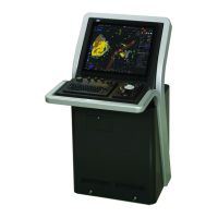
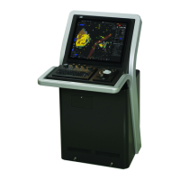
| Display | LCD |
| Beamwidth (horizontal) | 1.2° |
| Rotation Speed | 24/48 rpm |
| Power Supply | 24 VDC |
| Type | X-band |
| Frequency | 9410 MHz |
| Antenna Length | 6 ft |
| Range | 96 nautical miles |
| Display Size | 19 inches |
| Display Resolution | 1280 x 1024 pixels |