Do you have a question about the Leica Wild t1010 and is the answer not in the manual?
Procedure for centering the instrument using a tribrach with an optical plummet.
Procedure for centering the instrument using a tribrach without an optical plummet.
Guidance on pointing the instrument to a reflector for distance measurement using specific models.
Guidance on pointing the instrument to a reflector for distance measurement using specific models.
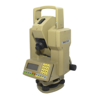
Details the keyboard layout, including color-coded keys and their functions.
Outlines the necessary preparations before taking the first measurement, including defining units.
Describes how to perform angle and distance measurements without data recording.
Explains how to compute target-point coordinates and height.
Procedure for determining and correcting the vertical-index error for improved accuracy.
Description of the REC module for data recording and its capacity.
Accesses the SET menu program for inputting station and target-point coordinates, REM words.
Accesses DATA functions to view recorded data and indicate the data file.
Procedure for adjusting the instrument to correct collimation error.
Method for computing atmospheric correction in ppm based on pressure and temperature.
Procedure for reducing distances to a certain level, accounting for Earth's curvature.
Method for calculating correction based on projection-scale factor for map projections.
| Brand | Leica |
|---|---|
| Model | Wild t1010 |
| Category | Laser Level |
| Language | English |