11
WIND 3100 Installation and Operation Manual
NAVMAN
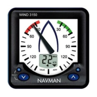
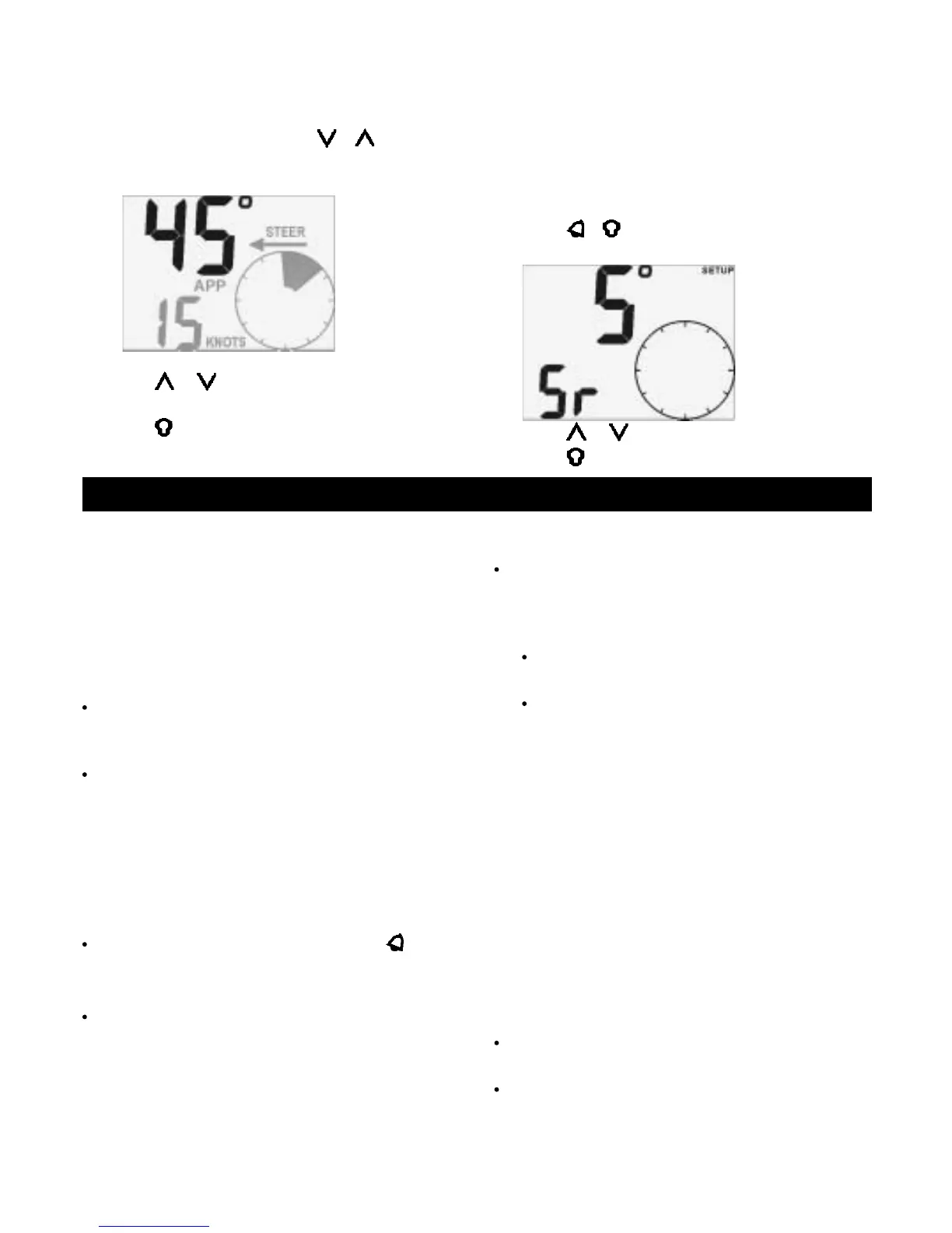
5-1 Set required steering angle
The required steering angle is the required angle
between the boat direction and the apparent wind
direction:
1 While steering to wind, press + ; the
required steering angle flashes:
2 Press
or to change the required steering
angle. The range is 0
° to 150°.
3 Press
.
5-2 Set steering resolution
In steer to wind, the circular pointer shows the steering
correction. The steering resolution is a number from 1
to 5 that sets the number of degrees of steering error
that each segment represents (see examples on
previous page).
Use a smaller steering resolution for more exact sailing.
To set the steering resolution:
1 Press
+ several times until the Steering
Resolution screen is displayed:
2 Press
or to change the resolution.
3 Press
.
Several NAVMAN instruments can be connected
together to share data. There are two ways of connecting
instruments together, NavBus or NMEA.
6-1 NavBus
NavBus is a NAVMAN proprietary system that allows
systems of multiple instruments to be built using a single
set of transducers. When instruments are connected
by NavBus:
If you change the units, alarms or calibration in
one instrument, then the values will automatically
change in all other instruments of the same type.
Each instrument can be assigned to a group of
instruments (see section 1, 8-2, step 3). If you
change the backlight in an instrument in group 1,
2, 3 or 4 then the backlight will automatically
change in the other instruments in the same
group. If you change the backlight in an
instrument in group 0 then no other instruments
are affected.
If an alarm sounds, mute it by pressing on any
instrument which can display that alarm.
NavBus and the WIND 3100
If the WIND 3100 does not have a masthead unit
fitted then the unit will automatically take wind
direction and speed readings from another
instrument, via NavBus, if the data is available.
For more information, refer to the NavBus
Installation and Operation manual.
If a masthead unit is not fitted to the unit and the
6 Systems of several instruments
corresponding external data is not available then
the displayed value will be dashes (— —).
To display true wind speed, true wind direction
and VMG, the WIND 3100 must be connected to
an instrument that outputs boat speed. Typical
instruments that output boat speed are:
A GPS receiver (outputs boat speed over
ground).
A NAVMAN SPEED 3100, which uses a
paddlewheel transducer (outputs boat speed
through water).
Note: If there is a current, these two speeds are
different.
You must select which type of boat speed the WIND
3100 will use (see section 3.1 and 8-2, step 2).
6-2 NMEA
NMEA is an industry standard, but is not as flexible
as NavBus as it requires dedicated connections
between instruments. Wind, speed and direction data
are output by the WIND 3100 and can be read and
displayed by the NAVMAN REPEAT 3100 or other
NMEA instruments. The WIND 3100 can receive
NMEA boat speed data:
RMC or VTG from any compatible GPS
instrument (speed over ground)
VHW from any compatible instrument with a
paddlewheel speed transducer (speed through
water).
You must select which type of boat speed the WIND
3100 will use (see section 3-1, 8-2, step 2).
Required
steering
angle is 45°
Steering
resolution
is 5°
 Loading...