Do you have a question about the Raymarine 435i and is the answer not in the manual?
Introduces the handbook's purpose and explains its conventions for controls and procedures.
Specifies the product's intended marine navigation use, warranty details, and accuracy disclaimers.
Discusses electromagnetic compatibility standards and the importance of correct installation for performance.
Explains optimal conditions for receiving GPS signals, emphasizing clear sky view.
Highlights installation safety, using the device as a navigation aid, and high voltage warnings.
Provides contact details for Raymarine technical support, service, and accessories.
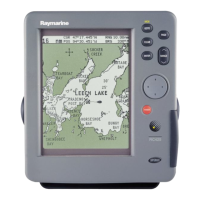
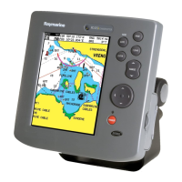
Describes the chartplotter's features, display layout, and basic operating controls.
Explains dedicated keys, status bar, function bar, and pop-up menu operations.
Details the SD system for GPS accuracy and explains how WAAS, EGNOS, and MSAS work.
Introduces the installation process, EMC guidelines, and suppression ferrite usage.
Covers unpacking, inspecting components, optional items, and mounting methods.
Provides specific instructions for installing the RC435 external and RC435i internal GPS antennas.
Discusses chartplotter mounting, cable routing, power, and NMEA connections.
Guides through system checks, initial power-on, and verifying chartplotter operation.
Introduces starting with the chartplotter and using its simulator mode for practice.
Describes switching the unit on/off and adjusting screen lighting and contrast.
Explains chart navigation, scale changes, display modes, and using FIND SHIP.
Provides information on inserting, loading, and displaying data from Navionics Gold Chart Cards.
Details settings for bearing, keys, units, variation, date, time, language, and simulator.
Covers orientation, plotter mode, waypoints, alarms, and chart display elements like contours.
Shows GPS status, options for SD-GPS mode, and how to reset the GPS system.
Explains placing, selecting, editing, erasing, and moving waypoints on the chart.
Covers creating, saving, clearing, retrieving, editing, and naming routes.
Describes following routes, target arrival, altering routes, and going to specific points.
Explains different display modes like CDI, BDI, Waypoint, Navigation, and Time/Date data.
Covers transferring data via NMEA/card and using tracks with SmartRoute.
Explains displaying port services, tidal data, and using the archive function.
Details the Man Overboard function and the chartplotter's alarm system.
Covers routine checks, servicing guidelines, and system reset procedures.
Provides troubleshooting guidance for common issues and contact information for support.
Lists the detailed technical specifications including dimensions, power, display, and GPS capabilities.
Provides a glossary of abbreviations used throughout the manual.
| Weight | 1.5 lbs (0.68 kg) |
|---|---|
| Built-in Chartplotter | Yes |
| Antenna | Internal |
| Geodetic Datums | WGS 84 |
| Receiver Type | GPS |
| Update Rate | 1 Hz |
| SBAS | WAAS/EGNOS |