14.15Laylines
Laylinesareusedinsailingtoshowhowfarthe
vesselmustsailonthecurrenttackinordertomake
thetargetwaypointaftertacking,givenpresent
windconditions.LaylinesarebasedontheTrue
WindDirection(TWD)andxedorpolarupwind
anddownwindsailingangles.Sailingalonglaylines
maximizesyourVelocityMadeGood(VMG)to
windward.
Laylinesaredisplayedunderthefollowingconditions:
•TheBoatTypesettingissettooneoftheavailable
sailingvessels
•Thevesselisunderactivenavigationtowardsa
waypoint
•Thelaylinepathtothedestinationpointisless
than150nm
•Theanglebetweenportandstarboardlaylinesis
lessthan170°
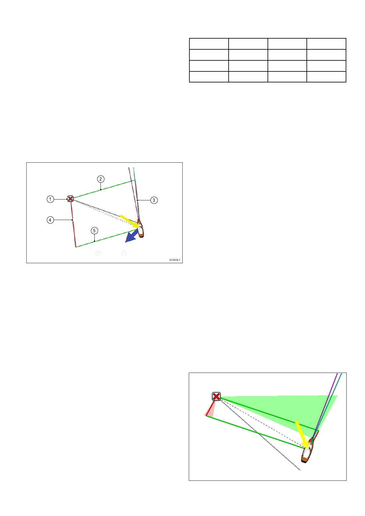
1.Destination
2.Starboarddestinationlayline
3.Portvessellayline
4.Portdestinationlayline
5.Starboardvessellayline
Laylinesappeardifferentlydependingondestination
pointandvesselpositioninrelationtothewind.
Whenthedestinationpointisupwindthelayline
parallelogramisdisplayedasshownabove.Once
yourvesselhaspassedthedestinationpoint
(andyouarereadytotack)only2sidesofthe
parallelogramwillbeshown.Ifthedestination
pointisdownwindthenonlythevessellaylinesare
displayedinthesamecolor,thisindicatesthebest
angletosail.
Laylinestypes
Thereare3typesoflaylines:
•MirroredTWA(TrueWindAngle)—thevectors
usecurrentTWAdatatocreatelaylinestoan
upwinddestinationpoint,thesearemirroredon
theoppositesideofthewind.Thisoptionshows
thecurrentcourseontheoppositetack.
•FixedAngles—thevectorsarecreatedbased
onspeciedUpwindandDownwindangles.
Theseanglesaresetbydefaultto45°and165°
respectivelyandcanbeconguredinthemenu.
•Polars—thevectorsuseanimportedpolartable
foryourvesseltocreatethelaylines.
Laylines-Leewaycalculations
TheLaylinesfeaturesusescalculationsbasedon
theselectedboattypetoworkoutleeway.
BoatType<5knots5to18knots>18knots
RaceSail3°upto5°5°
SailCruiser3°5°to10°5°
Catamaran3°10°to20°5°
Ifyourhullbehavesdifferentlythanexpectedtry
changingtheBoatTypesetting.
Enablinganddisablinglaylines
WiththeBoatTypesettingsettoeither,Sail
Cruiser,RaceSailorCatamaranLaylinescanbe
enabledanddisabled.
FromtheChartapplicationmenu:
1.SelectPresentation.
2.SelectVectors.
3.SelectLaylinessothatOnishighlightedto
enablelaylines,or
4.SelectLaylinessothatOffishighlightedto
disablelaylines.
Changinglaylinetype
FromtheChartapplication’sVectorsmenu:
1.SelectLaylinesSet-up.
2.SelectLaylinesType.
3.SelectthetypeofLaylinesyouwanttouse.
ThePolarsoptionisonlyenabledwhenaPolar
tablehasbeenimported.
Adjustinglaylinesfortidalow
Anoptionisavailabletoautomaticallyadjustthe
laylinestotakeintoaccounttidalow.
FromtheLaylinesSet-upmenu:
1.SelectAdjustforTidessothatOnishighlighted.
Displayinghistoricallaylines
Laylinespositionschangeovertimeduetoshifts
inwinddirection.Minimumandmaximumlaylines
positionscanbedisplayedoveraspeciedtime
period.
FromtheLaylinesSet-upmenu:
1.SelectMin&MaxLaylines:.
Chartapplication
187
 Loading...


