Do you have a question about the Raymarine RC435 and is the answer not in the manual?
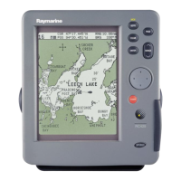
Describes the features and operating controls of the RC435/435i chartplotters.
Explains the satellite differential correction system used to improve GPS accuracy.
Provides guidance for planning the installation of the RC435/435i Chartplotter aboard a vessel.
Details the process of unpacking and checking all system components after purchase.
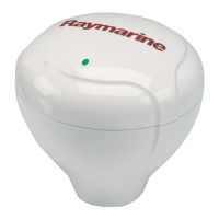
Provides instructions for mounting the external GPS antenna for the RC435 model.
Covers considerations and methods for installing the RC435/435i chartplotter unit itself.
Explains how to perform essential checks and turn on the system for the first time.
Describes the simulator mode for practicing chartplotter operation without live GPS data.
Details the procedure for powering the chartplotter unit on and off.
Explains how to manage and customize the chartplotter's display settings.
Details parameters for overall system functionality, including units, language, and beeps.
Covers chart-specific settings such as orientation, waypoints, and display options.
Explains how to view GPS status and manage satellite differential settings.
Details how to place, select, edit, erase, and move waypoints.
Covers creating, saving, editing, and managing routes.
Instructions for navigating along a route or to specific destinations.
How to switch between different data display screens.
Methods for moving waypoint and route data via NMEA or chart card.
How to record and manage the vessel's track history.
Procedure for marking and returning to a person or object lost overboard.
Explains the different types of alarms and how they are triggered.
Provides guidance on routine checks and safe servicing of the equipment.
Details the procedures for performing a Power-On Reset or a Factory Reset.
Offers a guide to identify and resolve common issues with the chartplotter.
Information on how to get support via the internet and phone.
Details about the GPS antenna and its capabilities.
Details of NMEA data transmitted and received by the device.
Course Over Ground.
Estimated Time of Arrival.
Man OverBoard.
Cross Track Error.