Do you have a question about the Raymarine RayChart 630 and is the answer not in the manual?
Warning about high voltages within the display unit requiring specialized service.
Disclaimer that the device is an aid to navigation and not a substitute for judgment.
Step-by-step instructions for powering the chartplotter on and off.
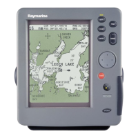
Instructions for using electronic chart cards to display detailed navigation information.
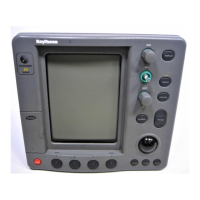
Procedure for inserting C-MAP NT electronic chart cards into the chartplotter.
Methods for controlling the chart display, including panning, scaling, and centering.
Important safety considerations when marking waypoints and navigating routes.
Guide to setting up and using on-screen routes for navigation.
Step-by-step guide to creating a new route directly on the chart display.
How to modify existing on-screen routes by adding or deleting waypoints.
How to follow, retrace, advance, or erase a selected route.
Initiating route tracking, reversing direction, and stopping navigation.
Function for setting a target point and initiating navigation towards it.
Function for setting a target point and initiating navigation towards it.
How to modify the name, symbol, and position of a new waypoint after requesting GO TO.
Options for switching to a new GO TO target or canceling the current navigation.
How to use marks and events to record features on the chart.
How to record, display, and manage the vessel's track history.
How to enable or disable the recording of the vessel's track history.
Procedure to quickly mark the vessel's position in case of a man overboard incident.
Configuration and management of navigational alarms and timers for safety.
How to access and manage the list of all stored waypoints and events.
How to access and view the list of all stored waypoints and events.
How to view the details and progress of the currently active route.
How to access and manage the list of all stored routes.
How to configure various operational parameters, including system defaults and navigation settings.
How to access and modify various system parameters via the SET UP menu.
Options for configuring system preferences, including language, units, and date/time.
Configuring navigational alarms for arrival, off-course, anchor, danger zone, and timers.
Details on enabling and setting limits for various navigational alarms like arrival and off-course.
How to customize screen layout, cartographic detail, and color settings.
Information on routine cleaning, periodical checks, and safety guidelines.
Troubleshooting guide for common issues and their solutions.
A table identifying common issues and corrective actions for restoring normal operation.
Guidelines for ensuring electromagnetic compatibility during installation.
Guidance on planning the installation, including location, connections, and cabling.
Instructions for physically mounting the chartplotter unit.
Details on connecting the chartplotter to power, GPS, NMEA, and SeaTalk systems.
Details on connecting power, NMEA in/out, and printer to the POWER connector.
How to connect the chartplotter to the vessel's DC power system, including fuse requirements.
Procedures for checking installation and performing initial system setup.
Pre-power on checks to ensure secure installation and correct connections.
Steps for powering on the unit and performing initial setup procedures.
Final checks to ensure the installation is unaffected by external radio transmissions or engine starting.