Do you have a question about the Raymarine RC400 and is the answer not in the manual?
Introduction and conventions used in the handbook.
Overview of the RC400 GPS Chartplotter and its features.
Explanation of terminology and symbols used in the handbook.
Specifies the intended purpose of the RC400 as a marine navigation aid.
Information on registering ownership and warranty benefits.
Disclaimer regarding the accuracy and potential changes in handbook information.
Details on Electromagnetic Compatibility standards conformance.
Guidance on optimal conditions for receiving GPS signals.
Important safety warnings and precautions for operation and battery usage.
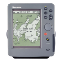
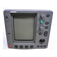
Details the features and functions of the RC400 GPS Chartplotter.
Lists the key display features and capabilities of the chartplotter.
Describes the physical controls and on-screen display layout.
Explains the satellite differential correction system for enhanced accuracy.
Details the operational principles of satellite differential systems like WAAS.
Information on the availability and status of differential GPS signal systems.
Notes on the responsibility and guarantee of satellite broadcast signals.
Provides guidance for planning the installation of the RC400 GPS Chartplotter.
Recommendations for optimal Electromagnetic Compatibility during installation.
Instructions for unpacking and checking system components.
Guidance on what to do if system components are missing or damaged.
Considers points for reliable and trouble-free installation of the unit.
Steps for installing batteries and the Navionics Gold Chart Card.
Procedure for installing Ni-MH or alkaline batteries into the battery tray.
Instructions on how to insert the Navionics Gold Chart Card.
Procedure for safely removing the Navionics Gold Chart Card.
Instructions for mounting the unit using the supplied bracket.
Guidance on routing power and NMEA cables.
Details on the power and NMEA connector pinout and usage.
Instructions for charging the Ni-MH batteries.
Explanation of the battery status icon and low battery indications.
Procedures for system check and initial power-on.
Steps to perform the initial power-on sequence.
Steps to verify correct operation after installation.
Final check for Electromagnetic Compatibility before use.
Final check on GPS signal reception after installation.
Guide to familiarizing with controls for routine navigation.
Explanation of the battery status icon and low battery indications.
Introduction to the simulator mode for practicing operation.
Procedure for powering the unit on and off.
How to adjust screen brightness and contrast levels.
Detailed steps to activate and use the simulator mode.
Describes how to change display modes and pan the chart.
Explains how to cycle through different display modes.
Information on using Navionics Gold Chart Cards for navigation.
Instructions for loading chart data from a Gold Chart Card.
How new chart data is displayed when moving across areas.
Overview of setting up the system according to user preferences.
Configuration options for system-wide settings.
Configuration options for chart-specific settings.
Information and settings related to GPS status and satellite selection.
Explains how to use the chart functions for navigation.
Detailed guide on creating, editing, and managing waypoints.
Instructions on how to place new waypoints on the chart.
How to select a waypoint to view options or edit it.
Methods to view detailed information for a selected waypoint.
Procedure for changing waypoint name, symbol, and position.
Steps for deleting waypoints from the system.
Instructions on how to relocate existing waypoints.
Guide to creating, managing, and following routes.
Steps to create a new route by adding waypoints.
Procedure for saving the current route to the database.
How to remove the current route display.
Steps to load a saved route from the database.
How to view details about route legs and waypoints.
Procedures for deleting or renaming saved routes.
Accessing detailed information about route waypoints.
Guidance on following routes and navigating to specific points.
Steps to initiate following a selected route.
How to reverse an existing route for return navigation.
Explanation of target point arrival alarms and procedures.
Options for modifying a route, including joining and advancing.
How to start following a route from a selected waypoint.
Procedure to move to the next waypoint in a route early.
Resets Cross Track Error, useful when off-track.
Direct navigation to a specific waypoint, port, or cursor position.
Steps to navigate directly to a chosen waypoint.
Navigating directly to the current cursor position.
Instructions for navigating to the nearest or a selected port.
How to switch between different display modes.
Course Deviation Indicator display showing cross track error.
Bearing Deviation Indicator display showing bearing and distance.
Methods for transferring data via NMEA or Gold Chart card.
Receiving and transmitting waypoints via NMEA link.
Functions for sending and receiving waypoint/route data.
Guide to recording, clearing, and converting tracks.
Instructions for enabling track recording and setting intervals.
Procedure for clearing the current track from screen and memory.
Function to convert a track into a route.
How to display detailed information about chart objects.
Saving routes, tracks, and waypoints to the Gold Chart card.
Steps to save a route to the Gold Chart card.
How to load, delete, or rename routes from the archive.
Steps to save a track to the Gold Chart card.
How to load, delete, or rename tracks from the archive.
Steps to save a set of waypoints to the Gold Chart card.
How to load, delete, or rename waypoint sets from the archive.
How to view information about charted objects like ports and tides.
Instructions for displaying detailed port service information.
How to display tidal height and current information.
Procedure for activating Man Overboard mode.
Description of the chartplotter's various alarm types.
Information on routine maintenance procedures.
Periodic checks to ensure the unit and cables are in good condition.
Guidelines for servicing and general safety when using the equipment.
Methods for resetting the chartplotter to default or cleared states.
Guidance on identifying and resolving common issues.
A table of common problems and their recommended corrections.
Information on how to get technical support and contact Raymarine.