Do you have a question about the SEPTENTRIO Altus NR2 and is the answer not in the manual?
Basic introduction to the Altus NR2 and its benefits.
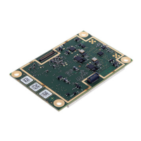
Details the Altus NR2's specifications and GNSS capabilities.
Important information for users regarding product usage.
Outlines product warranty, service, and contact information.
Covers CE, ROHS, and WEEE compliance.
Details compliance with FCC rules and RF exposure.
Explains Industry Canada compliance and RF exposure.
Lists essential safety warnings and instructions for the device.
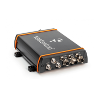
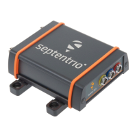
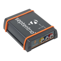
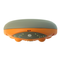
Describes the layout and LEDs on the front panel.
Explains how to use the power button for various operations.
Identifies the slots for batteries and the SIM card.
Details the device's main connection port.
Introduces the functionality of the web interface.
Lists necessary items and services before starting.
Step-by-step guide for SIM card insertion.
Instructions for correctly inserting the device batteries.
Describes the procedure to switch on the Altus NR2.
How to enable and check the Wi-Fi radio status.
Steps to access and use the device's web interface.
Initial steps for configuring RTK mode.
Configuring the device's cellular modem.
Setting up the device as an NTRIP client.
Verifying the RTK setup status.
Establishing a Bluetooth connection.
Configuring NMEA messages for Bluetooth.
Enabling and configuring data logging.
Customizing logging parameters.
Adjusting the antenna offset for accurate positioning.
Saving configuration to boot.
Disabling Wi-Fi to conserve battery.
Downloading logs using the web.
Downloading logs via USB.
Accessing interface via USB.
Defining the static position for base operation.
Setting up RTK via cellular.
Setting up RTK via Wi-Fi.
Overview of GIS data collection features.
Steps for creating maps in ArcGIS Online.
Ensuring internet access for GIS features.
Detailed guide to the web interface.
Automating attribute population.
Using the mobile GIS application.
Covers battery swapping and charging.
Covers configuration, reset, upgrade, console, and about.
Managing device settings and profiles.
Device reset and firmware updates.
Accessing and using the command line.
Viewing hardware and software details.
Explaining icons in the web interface.
Understanding front panel LED indicators.
Specifics about batteries.
Commands for cellular modem configuration.
Definitions of GIS and PinPoint-GIS terms.
List of common GNSS abbreviations.
| Type | GNSS Receiver |
|---|---|
| Constellations | GPS, GLONASS, Galileo, BeiDou, QZSS, SBAS |
| RTK Accuracy (Horizontal) | 8 mm + 1 ppm |
| RTK Accuracy (Vertical) | 15 mm + 1 ppm |
| Static Accuracy (Vertical) | 5 mm + 0.5 ppm |
| Velocity Accuracy | 0.03 m/s |
| Time Accuracy | 20 ns |
| Data Output Rate | up to 100 Hz |
| Power Supply | 9-36 VDC |
| Frequency Bands | L1, L2, L5 |
| Channels | 672 |
| Data Logging | Internal memory |
| Connectivity | Ethernet, USB |
| Communication Interfaces | Serial, Ethernet, USB |
| Operating Temperature | -40 °C to +65°C |