Do you have a question about the Standard Horizon CP180 and is the answer not in the manual?
Describes chart accuracy and the importance of using official nautical charts.
Details FCC regulations for digital devices and potential interference.
Advises on maritime use, water intrusion, heat exposure, and high voltage circuits.
Provides step-by-step instructions for cleaning the GPS Chart Plotter screen.
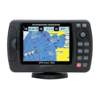
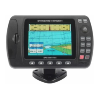
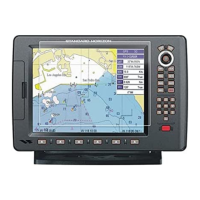
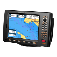
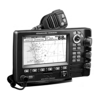
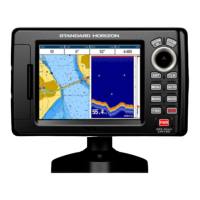
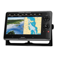
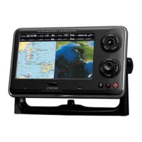
Describes the GPS Chart Plotter's features, benefits, and design.
Lists the standard items included with the CP180/CP180i models.
Lists available optional accessories for the GPS Chart Plotter.
Covers bracket and flush mounting procedures for the device.
Details the process for flush mounting the CP180 and CP300 models.
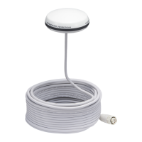
Covers the installation of the external GPS antenna.
Details wiring for power supply and NMEA devices.
Explains power and NMEA connections for CP300/CP300i models.
Details DC power and video input connections for CP180/CP180i.
Describes how to connect fish finder, AIS, VHF, and autopilot.
Details connections for various peripherals on CP300/CP300i.
Explains fuse installation and power connection to a 12VDC source.
Lists external devices that can connect via NMEA.
How GPS data integrates with VHF radios for DSC calls.
Mentions optional fish finder and radar units.
Details connecting the GPS Chart Plotter to a PC for data transfer.
Explains how to monitor NMEA data transmission from external devices.
Describes connecting video cameras, VCRs, or DVDs to the device.
Details menu options like Full Screen, PiP, and Auto Switch.
Explains how to activate and use demo mode for dealer demonstrations.
Describes keys like ZOOM, MENU, GOTO, and the ShuttlePoint knob.
Explains the function of soft keys for page selection.
Covers basic power functions and ShuttlePoint knob navigation.
Describes when the cursor icon is shown on the chart page.
Describes when the ship icon is shown on the chart page.
Explains how to change cursor movement speed via the menu.
Details how to select different ship icons for vessel representation.
Covers adjusting screen brightness and contrast.
Explains how to orient the chart display to North or Course Up.
Describes how to set time zones and daylight saving options.
Explains how to change coordinate display (Lat/Lon, UTM, Loran TD).
Covers changing chart display colors (Sunlight, Normal, Night).
Details how to select the display language for menus and charts.
Explains how soft keys are used to navigate between display pages.
Describes how to reassign soft key functions for quick access.
Details settings like Time, Date Format, Keypad Beep, Units, Nav Aids.
Explains how to access software, cartography, and storage details.
Introduces the INFO key for searching cartographic data.
Details how to find available port services near the vessel.
Explains how to find and view information about nearby ports.
Describes how to find and view tide station data and graphs.
Details how to find wreck icons and access their information.
Explains how to find obstruction icons and access their information.
Details how to find lake information and outdoor recreational areas.
Explains how to get quick information on lake objects.
Describes how to view detailed lake information.
Explains how to search for lakes by name.
Details how to search for points of interest by category and type.
Describes how to find stored marks and waypoints by name.
Explains how to enter and view coordinates on the chart.
Details how to retrieve information about any position on the chart.
Provides instructions on inserting the C-MAP C-CARD.
Lists cartography features like ISO Certification and Extra Large Coverage.
Describes features like Clear View, Flexi-Zoom, and Perspective View.
Explains Guardian Alarm, Safety Status Bar, and Safety Route Check.
Introduces the Max Functions menu for chart display settings.
Explains how to change the size of icons on the chart.
Details how to change the size of place names on the chart.
Describes how to switch to a bird's-eye view of the chart.
Explains how Nav-Aids blinking works based on range.
Describes the safety status bar and its indicators.
Details how to overlay satellite images on the map.
Explains how to view tidal stream data indicating direction and strength.
Describes how to select the display language for chart information.
Explains how to show pictures and diagrams of multimedia objects.
Details how to view pictures and diagrams associated with chart objects.
Explains how to access enhanced port service data like location and contacts.
Details the process of placing a mark on the chart using Lat/Lon.
Explains how to modify existing marks, including name, icon, and position.
Describes how to remove marks or waypoints from memory.
Explains how to reposition marks or waypoints.
Details list management functions: sort, find, send, receive.
Explains how to create a new mark using the user points list.
Describes how to initiate navigation to a cursor, route, or mark.
Explains how to select and navigate to a saved route.
Details how to select and navigate to a saved mark.
Describes how to mark the Man Overboard position.
Explains how to remove a MOB mark from the chart and list.
Details how to create a route by adding waypoints.
Explains how to assign a custom name to a route.
Describes the process for creating an Olympic route.
Details how to create more than one route.
Explains how to build routes using marks instead of waypoints.
Describes how to choose and select a route to follow.
Explains how to start navigation to a route using the cursor.
Details how to remove a route from the system.
Explains how to check a route for potential dangers like shallow water or wrecks.
Details parameters like Route Width, Depth Limit, and Accuracy.
Explains the capability to store and record tracks and track points.
Describes how to configure track recording intervals (distance/time).
Details the process for saving and starting a new track.
Explains how to view trip log data and reset it.
Details the procedure for selecting units and resetting the trip log.
Explains the use of the C-CARD for backing up marks, routes, and tracks.
Describes the items available in the C-CARD menu.
Details the process for formatting the C-CARD before use.
Explains how to save data to the C-CARD.
Details how to load data from or delete files from the C-CARD.
Introduces the various pages available for navigation and data display.
Describes how to choose between single and dual chart displays.
Explains how to use the Focus soft key on dual chart pages.
Details how to change focus between windows on dual chart pages.
Explains how to choose different window layouts for the chart page.
Details how to change the data displayed in chart windows.
Mentions icons for buoys, lights, wrecks, and tide stations.
Explains how to turn auto info on or off for chart objects.
Describes different display modes for cartographic objects.
Details settings for Place Names, Nav Aids, Attention Areas, Tides & Currents.
Explains settings for depth range and area display.
Details settings for land elevations, roads, and points of interest.
Covers settings for Lat/Lon Grid, Chart Boundaries, and Value Added Data.
Explains how to display underwater objects like rocks and wrecks.
Details customizing chart items instead of using predefined modes.
Explains how to show navigation data with compass rose or tape.
Describes the Highway page's 3D view for navigation.
Explains how to view tide and moon phase data.
Explains how to check GPS satellite reception and status.
Details how to enable or disable WAAS/EGNOS correction sources.
Covers internal GPS, restart, and navigation speed settings.
Explains how to display data from external NMEA devices.
Details how to check NMEA data transmission from external devices.
Explains how to view trends for depth, wind, temperature, and speed.
Describes the DSC system for VHF radio calls.
Details wiring connections for DSC VHF radios.
Explains how to send a distress call with GPS position.
Describes how to request and display a vessel's position.
Details NMEA port configuration for various devices.
Covers Coordinate System, Map Datum, and Map Orientation Resolution.
Explains how to enter Loran TD coordinates.
Covers compass calibration and alarm setup.
Details alarm types like Arrival, XTE, Depth, Anchor, Grounding.
Explains how to use the simulator for practice.
Describes simulating route navigation in simulation mode.
Explains Auto Position and Auto Info for DSC polling.
Defines AIS terms like Target, CPA, TCPA, MMSI.
Covers AIS display and alarm settings.
Explains how to set up the plotter to receive AIS data via NMEA.
Describes viewing information by placing the cursor over an AIS target.
Explains how to display and select targets from the AIS list.
Introduces the free C-Weather service and its features.
Details how to access the C-Weather menu.
Explains how to download weather data via C-COM or C-CARD.
Describes loading weather data from the User C-CARD.
Details options for viewing forecasts, real-time data, and data types.
Explains how to connect the MOBILARM system to the GPS Chart Plotter.
Details the steps to configure the GPS Chart Plotter for MOBILARM.
Explains how to check MOBILARM status messages.
Introduces the PTX personal transponder device.
Describes what happens when a MOB alert is received.
Explains how to view information by placing the cursor over the PTX icon.
Details how to remove a PTX from the chart and list.
Explains how to navigate to a PTX location.
Describes how to view the list of MOBILARM alarms received.
Explains the functions available from the alarm list (Goto, Delete, Show).
Addresses issues with the device not powering on.
Covers problems with getting a valid GPS fix and power cycling.
Addresses screen dimming and non-responsive commands.
Introduces the system test for diagnosing device problems.
Explains how to run the system test.
Details RAM clearing and contrast/backlight adjustments.
Describes tests for the C-CARD and its connector.
Covers serial port parameter changes and loop-back tests.
Lists technical specifications for the CP180/CP180i models.
Lists technical specifications for the CP300/CP300i models.
Lists the specifications for the optional WAAS GPS receiver.
Defines various terms related to GPS and navigation.
Defines terms related to altitude, wind, and direction.
Defines terms related to GPS precision, tide height, water temperature, and units.
Defines terms related to Digital Selective Calling, distance, ETA, and GPS.
Defines terms related to GPS precision, pingo, position requests, and speed.
| Display Size | 5 inches |
|---|---|
| Waterproof Rating | IPX7 |
| GPS Receiver | 12 Channel WAAS |
| Chart Plotter | Yes |
| Dimensions | 150 x 98 x 45 mm |
| Weight | 0.7 kg |
| Backlight | Yes |
| Memory | Internal and C-MAP NT+ compatible |
| Power Supply | 12V DC |
| NMEA 0183 | Yes |
| Display Type | TFT LCD |
| Accuracy | 3 meters |
| SBAS | WAAS |
| Chart Compatibility | C-MAP |