How
to interpret the Along TLackjCro-ttrack Error chart
he illustration shows four flight
parns
to
waypoints bein offset varying
distances from the VOdAC. You will
note that in flight path
1
the offset dis-
tance is zero; the waypoint, in other
words, is located Over the VORTAC.
In this case, the along track and cross-
track error is minimal. This is because
the along track error is totally derived
from the DME and the crosstrack error
is from the VOR.
Please note that the along track
and crosstrack errors increase in
fli
ht
paths
2,3,
and
4
as the waypoint
of-
set
perpendicular
to
the flight path
increases. For example, on flight path
&where the waypoint is offset 100 nm
perpendicular
to
the flight path and the
aircraft is 100 nm from the waypoint-
the aircraft can be anywhere within a
5.7
nm square when the crosstrack needle
is centered and the along track (dis-
tance) indicator
is
showing exactly
100 nm to go.
In summary, the illustration shows
that the accuracy of the RNAV
s
stem
is poorest when the wa point o&et
distance and the aircrai distance from
the VORTAC station is large. On the
other hand, the RNAV accuracy is
greatest when the waypoint offset
distance and the distance from the
VORTAC station is small.
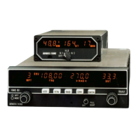
KNS
81
System
applications
In addition
to
conventional VORl
DMElLOClGS functions, the KNS 81
system provides many advantages
related
to
RNAV navigation:
Direct route navigation from point of
origin to destination-without following
the frequently circuitous Victor airways-
is a basic use of RNAV. Determine your
most
direct route and
set
up as many as
10 waypoints at intervals along that route.
(Remember: The KNS 81 stores all of
the waypoint parameters nm- radial,
distance,
and
frequency. Other systems
store only radial and distance, thereby
requiring you
to
change both the radial/
distance data and the frequency in order
to
activate a new waypoint.)
Location
of
afrflelds
that are
not
equipped with navigation aids is a
common use of RNAV. Simply locate the
airfield on your navigation chart and
place a waypoint at that location.
Set
up
a
holding
pattem
at any
geographic point convenient
to
you or
ATC. Establish a waypoint at that location,
then fly your pattern just as if
it
were a
real VORTAC station, using your course
deviation needle and DME for reference.
Locate
weather
kseb
reported
by
Flight Service or Air Traffic Control.
Establish a waypoint at that location and
fly directly
to
it.
ADIZ
or
restricted areas. Establish a
waypoint at your planned point of
penetration, then fly directly
to
that way-
point. You will be provided continuous
~IIW
pcMetratia
timeof
distance and time-to-waypoint infor-
mation with your KNS 81.
A parallel
mute
to
an alway
may be established simply by using the
KNS 81 in the VORlPAR mode and main-
taining a constant course deviation on
your CDI (1 nm per dot, up to
+-
5
nm full-
scale). A parallel route
to
the airway but
farther out may
be
accomplished by
establishing waypoints the Same distance
out from each of the VORTAC stations
that define the airway.
PoclRlon
mports
requested by
ATC often come during periods of heavy
pilot workload. With the KNS 81, you can
use the CHK Button feature
to
get an
immediate readout of radial and distance
from the VORTAC station even when in
the RNAV mode.
Radial
from
the
waypblnt,
VORTAC
or
VOR
If you wish
to
know
the radial from the waypoint, VORTAC
or VOR without disturbing your
OS,
simply depress the
RAD
Rufloritand the
system will provide you hh’distwtce
and radial information from a waypoint
or VORTAC station.
SIDs, and STARS are available from NOS
or Jeppesen.
RNAV
charts
for RNAV Approaches
13