30
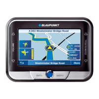
Route guidance
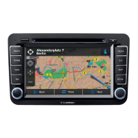
Route guidance with map display
When you use route guidance with the map display, you can select a map showing
your position surroundings (current vehicle position) or the destination surroundings.
The map showing your position surroundings changes in its alignment to indicate your
driving direction or can be made to point due north. In addition, you can select map
display with “Junction zoom”. This means that the small scale used during route guid-
ance, e.g. 0.5 mi, will automatically switch to a larger scale, e.g. 0.1 mi, when you
approach a junction. After you have completed the turn, the map will automatically
revert to the scale used previously.
In addition, you can also conveniently select an overview map to show the entire
route.
In each of the different map modes, it is also possible to display other additional infor-
mation, such as driving time, driving distance, petrol stations, car parks and tourist
attractions.
For more information on route guidance with map display, refer to the “Quick Refer-
ence”, “Example of route guidance with map display”.
Activating the map display
1. If route guidance last used the arrow symbols mode, you can easily switch to
the map mode. Press
OK
during the arrow symbols mode.
A selection menu will appear on the bottom left edge of the display. ✔
2. Mark “Map”. Press
OK
.
Route guidance will continue in map mode. ✔
 Loading...