Do you have a question about the Garmin 400/500 and is the answer not in the manual?
Direct links to frequently accessed topics and their page numbers for quick navigation.
Provides helpful navigation tips and shortcuts for using the unit's interface.
Explains symbols, terminology, and conventions used throughout the manual for clarity.
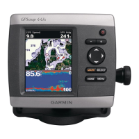
Identifies and describes the physical components, ports, and features of the GPSMAP units.
Instructions on powering the unit on/off and configuring initial settings like language and data.
How to adjust screen brightness, modes, and use the keypad for unit navigation and control.
Details on acquiring satellite signals, using simulator mode, and viewing system information.
Procedures for restoring factory settings and inserting/removing SD cards for data.
Explains the main interface and how to access different screens and features from Home.
Description of the primary chart view for planning courses and viewing navigation data.
Accessing options like full screen, waypoints, tracks, and data bar customization.
Utilizing split navigation charts and 3D perspectives like Perspective 3D for enhanced views.
Adjusting map detail, spot depths, safety shading, symbols, and points of interest display.
Setting the heading line and adjusting map orientation like North Up or Head Up.
Using Mariner's Eye 3D, Fish Eye 3D, and Fishing Charts for detailed marine data.
Accessing satellite imagery, aerial photos, POI data, and using automatic guidance.
Viewing chart and sonar simultaneously and understanding Automatic Identification System (AIS).
Understanding AIS targeting symbols and the projected course of activated AIS targets.
Search for and navigate to waypoints, routes, services, and specific destinations.
Store, create, edit, and manage up to 1,500 waypoints with detailed information.
Create and store up to 20 routes with up to 250 waypoints each, including automatic guidance.
Record, save, and manage your path as a track log for later review.
Utilize features of BlueChart g2 Vision SD cards and integrate with a Garmin Autopilot.
Accessing compass, numerical data, trip information, and fuel gauges from the dashboard.
Viewing tide-station and current information, and accessing saved user data like waypoints.
Configure system settings, units of measure, and navigation preferences for optimal performance.
Set up communications like NMEA, DSC, and configure various audible alarms.
Configure boat parameters like keel offset and settings for other vessels (AIS/DSC).
Understanding full screen, split frequency, and split zoom sonar views for fishfinding.
Viewing temperature logs and setting up sonar parameters like scroll speed and noise rejection.
Fine-tuning sonar with range, gain, frequency, zoom, and noise rejection for better detail.
Integrate chartplotter with VHF radio for GPS position transfer and DSC calling capabilities.
Turn DSC on/off, add contacts, view DSC list, and manage incoming distress calls.
Handle man-overboard distress calls and track vessels sending position reports.
Place individual routine calls and communicate with AIS targets via the chartplotter.
Receive and display weather data like NEXRAD, storms, marine warnings, and forecasts.
Understand storm cells, lightning, hurricanes, marine/county warnings, and weather fronts.
Listen to XM audio channels through the connected receiver and manage playback.
Details physical dimensions, weight, display, case, and temperature range of the unit.
Provides required clearance distances for compasses near the unit.
Details receiver performance, acquisition times, WAAS accuracy, power, and sonar capabilities.