EasyManua.ls Logo

Garmin GPS Map 76 User Manual

Garmin GPS Map 76
28 pages
To Next Page IconTo Next Page
Page #1 background imageLoading...
Page #1 background image
NRI Grazing Land On-Site Data Collection
(03/23/20011) B-1
Appendix B
The Garmin GPS Map 76 Receiver: Features, Functions,
Setup, and Quality of Position
Garmin GPS Map76 Features
Specifications
Weight: 7.5 ounces
No. channels: 12 parallel
Antenna type: Quad Helix
Display size: 180 x 240 pixels
Included map base: North America major highways, cities, exits accepts optional
Map Source ™ enhanced maps
No. Waypoints: 500 with name and graphical symbol
No. Tracks: 10 saved, about 10,000 total track points, auto logging
No. Routes: 50 comprised of 50 waypoints each
Rugged standard: IPX 7 waterproof floats on surface!
Other features: Trip computer, tidal info, sun/moon info, hunting/fishing info
Manual, pg. 4 and: http://www.garmin.com/products/gpsmap76/spec.html.
GPS Map 76 Front View
Visible on the front side of the Map76 is the:
Antenna always hold the receiver upright with the display facing you and the
antenna at about an 80 degree angle from horizontal. Face towards the southwest to
obtain the best GPS reception.
Screen protector Provides international patent information and a reminder of how to
orient the receiver for best GPS satellite reception.
Keypad A ROCKER key surrounded by 8 functional keys.
Display Display capable of depicting GPS data and 4 grey color maps.
Question and Answer IconNeed help?

Do you have a question about the Garmin GPS Map 76 and is the answer not in the manual?

Garmin GPS Map 76 Specifications

General IconGeneral
BrandGarmin
ModelGPS Map 76
CategoryReceiver
LanguageEnglish

Summary

Garmin GPS Map 76 Overview

Garmin GPS Map76 Features

Lists key specifications like channels, display, map base, and waypoint capacity.

GPS Map 76 – Front View

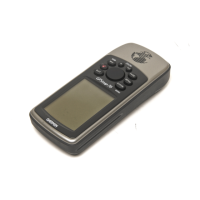
Details the components visible on the front of the device, including antenna and keypad.

GPS Map 76 – Back View

Describes the rear of the device, including antenna port, battery compartment, and data port.

Map 76 Interface Keys and Navigation

Map 76 Interface Keys

Explains the function of each physical button for device operation and navigation.

Map 76 Main Display Pages

Outlines the various screens available for data viewing and navigation.

Navigation – Localizing the Target

Provides instructions for accurately navigating to a specific point or destination.

GPS Map 76 Setup and Configuration

GPS Map 76 Setup

Introduces the process of configuring device settings.

General Tab Options

Configures mode, WAAS, beeper, language, and backlight timeout settings.

Time Tab Options

Sets time format, time zone, daylight savings, current date, and time.

Units Tab Options

Configures measurement units for elevation, depth, distance, speed, and direction.

Location Tab Options

Sets location format, map datum, north reference, and magnetic variation.

Alarms Tab Options

Configures settings for various warning alerts like off-course and proximity.

Interface Tab Options

Manages serial data format for communication with computers and other devices.

Quality of Position and Initialization

How to hold the receiver

Proper orientation and positioning for optimal satellite signal reception.

Initializing the Map 76 Receiver

Steps for initial setup, including acquiring satellites and setting a new location.

Using the GPS Information Page to determine quality of position

Interpreting the satellite sky plot and accuracy field for positional quality.

Related product manuals