Device Specification Measurement
Max. routes 100
Max. active track points 50,000 points, 50 saved tracks
Memory card 2 SD
®
card slots; 32 GB max.
card size
Wireless frequency and
protocols
Wi‑Fi
®
, ANT
®
, and Bluetooth
®
technologies
2.4 GHz @ 17.6 dBm nominal
Seven-inch
models
Dimensions (W × H ×
D)
224 × 142.5 × 53.9 mm
(8
13
/
16
× 5
5
/
8
× 2
1
/
8
in.)
Display size (W × H) 154 × 86 mm (6.1 × 3.4 in.)
Weight 0.86 kg (1.9 lb.)
Compass-safe distance 71 cm (28 in.)
Max. power usage at
10 Vdc
24 W
Typical current draw at
12 Vdc
1.5 A
Max. current draw at
12 Vdc
2.0 A
Nine-inch
models
Dimensions (W × H ×
D)
256.4 × 162.3 × 52.5 mm
(10
1
/
8
× 6
3
/
8
× 2
1
/
16
in.)
Display size (W × H) 197 × 114 mm (7.74 ×
4.49 in.)
Weight 1.14 kg (2.5 lb.)
Compass-safe distance 76 cm (30 in.)
Max. power usage at
10 Vdc
27 W
Typical current draw at
12 Vdc
1.3 A
Max. current draw at
12 Vdc
2.3 A
Sonar models Frequencies
2
Traditional: 50/200, 77/200,
83/200 kHz
Single Channel CHIRP: from
40 to 240 kHz
Garmin ClearVü CHIRP:
260/455/800 kHz
(dependent on transducer)
Transmit power
(RMS)
3
CHIRP: 1000 W
Garmin ClearVü and SideVü
CHIRP: 500 W
Depth
4
5,000 ft. at 1 kW
1
The device withstands incidental exposure to water of up to 1 m
for up to 30 min. For more information, go to www.garmin.com
/waterrating.
2
Dependent upon the transducer.
3
Dependent upon the transducer rating and depth.
4
Dependent upon the transducer, water salinity, bottom type,
and other water conditions.
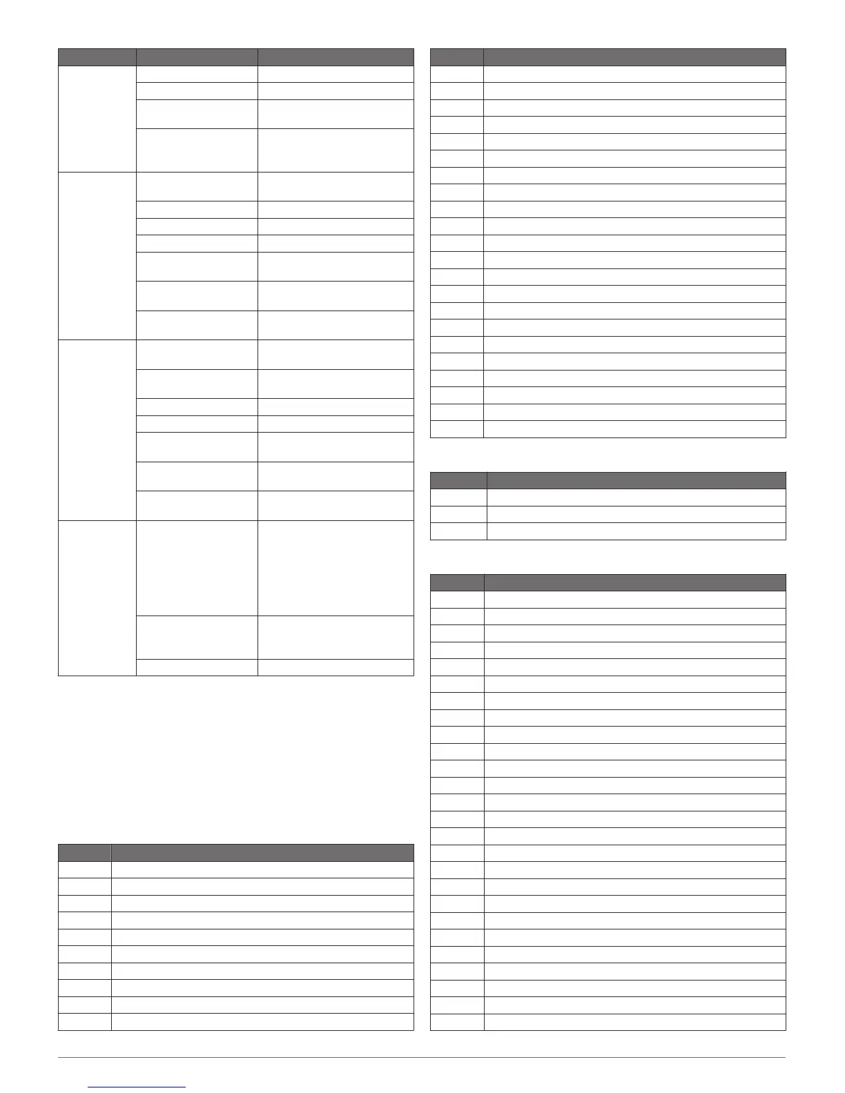
NMEA 2000 PGN Information
Transmit and Receive
PGN Description
059392 ISO acknowledgment
059904 ISO request
060160 ISO transport protocol: Data transfer
060416 ISO transport protocol: Connection management
060928 ISO address claimed
065240 Commanded address
126208 Request group function
126996 Product information
126998 Configuration information
127237 Heading/track control
PGN Description
127245 Rudder
127250 Vessel heading
127258 Magnetic variance
127488 Engine parameters: Rapid update
127489 Engine parameters: Dynamic
127493 Transmission parameters: Dynamic
127505 Fluid level
127508 Battery status
128259 Speed: Water referenced
128267 Water depth
129025 Position: Rapid update
129026 COG and SOG: Rapid update
129029 GNSS position data
129283 Cross track error
129284 Navigation data
129539 GNSS DOPs
129540 GNSS satellites in view
130060 Label
130306 Wind data
130310 Environmental parameters (obsolete)
130311 Environmental parameters (obsolete)
130312 Temperature (obsolete)
Transmit
PGN Description
126464 Transmit and receive PGN list group function
126984 Alert Response
127497 Trip parameters: Engine
Receive
PGN Description
065030 Generator average basic AC quantities (GAAC)
126983 Alert
126985 Alert text
126987 Alert threshold
126988 Alert value
126992 System time
127251 Rate of turn
127257 Attitude
127498 Engine parameters: Static
127503 AC input status (obsolete)
127504 AC output status (obsolete)
127506 DC detailed status
127507 Charger status
127509 Inverter status
128000 Nautical leeway angle
128275 Distance log
129038 AIS class A position report
129039 AIS class B position report
129040 AIS class B extended position report
129044 Datum
129285 Navigation: Route, waypoint information
129794 AIS class A static and voyage related data
129798 AIS SAR aircraft position report
129799 Radio frequency/mode/power
129802 AIS safety-related broadcast message
129808 DSC call Information
6

 Loading...
