ZOOM
IN
ZOOM
OUT
Setup
Press the POWER Key to turn the GPS unit on.
Press the MENU Key twice to open up the Main Menu.
Use the ROCKER Key to highlight the ‘Setup’ option. Press
ENTER Key to open Setup Menu.
Check the following settings:
Unit Tab
General Tab Elevation set to ‘Feet’
WAAS set to ‘Disabled’ Depth set to ‘Feet’
WASS set to ‘Enable’ Distance & Speed set to ‘Statute’
without the backpack
Time Tab Location Tab
Time Format set to ’12 hr’ Location Format set to
Time Zone set to ‘Central’ ‘hdddmm.mmm‘
Daylight Savings Time set Map Datum set to ‘NAD83’
to ‘Auto’ North Reference set to ‘True’
Interface Tab
Serial Data Format set to
‘RTCM In/NMEA Out’
RTCM In/NMEA Out
Beacon set to ‘User’
Baud
Beacon set to ‘User’
4800
Frequency set to a GPS
Beacon Freq Bit Rate
Broadcast site based
User _ _ _._ 200
on your current location
Status
and quality of reception
Receiving
(see the next page)
SNR Distance
Bit Rate set to ‘200’
_ _ _ _ _ _
Serial Data Format set to
‘Garmin’ without the backpack
Acceptable Accuracy Ratings
Review the following items to verify that the GPS unit is
receiving data at an appropriate level of accuracy.
On the GPS Information page
Accuracy - 5 meters (16.4 feet) or less
Receiver status – receiving
Main Menu Options
• Press the MENU Key twice
to display the Main Menu
page.
• Use the ROCKER Key to
highlight the menu option
desired.
• Press the ENTER Key to
display the page for the
selected option.
Trip Computer – Provides eight trip information data fields and
allows you to reset the fields.
Tracks – Allows you to ‘Save’ or ’Clear’ the Track Log, display
list of Saved Tracks, and setup the Track Log recording options.
Points – Allows you to select Waypoints, Points of Interest,
Cities, Exits, Addresses, and Intersections using your current
location.
Routes – Allows you to create routes, determine how many
routes you have left, view a list of existing routes, and review
and edit routes.
Proximity Waypoints – Allows you to enter a waypoint and
radius to alert you when approaching a predetermined area.
Celestial Menu – Allows you to view information on Tides, Sun
and Moon, and Hunt and Fish times.
MapSource Information – Displays a list of MapSource data
stored in the unit and allows you to turn On/Off the display of
each map.
System Information – Displays the software version and unit
ID number.
Setup Tabs – Allows you to set unit features such as time, units
of measure, location, alarms, interfaces, etc.
Differential GPS Broadcast Sites for Iowa
OMAHA, NE
Transmission Frequency: 298 KHZ
Transmission Rate: 200 BPS
KANSAS CITY, MO
Transmission Frequency: 305 KHZ
Transmission Rate: 200 BPS
ST. PAUL, MN
Transmission Frequency: 317 KHZ
Transmission Rate: 200 BPS
ROCK ISLAND, IL
Transmission Frequency: 311 KHZ
Transmission Rate: 200 BPS
ST. LOUIS, MO
Transmission Frequency: 322 KHZ
Transmission Rate: 200 BPS
This document was developed by the USDA-NRCS, Des Moines,
Iowa and was derived from the
Garmin GPSMap 76 Quick
Reference Guide
.
The USDA is an equal opportunity employer and provider.
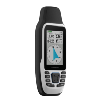
Garmin GPSMAP 76
Quick Reference Guide
IN – The ZOOM IN Key is used to decrease the
map scale. This allows you to view a smaller area
of the map, but with greater detail.
OUT – the ZOOM OUT Key is used to increase the
map scale. This allows you to view a larger area of
the map, but with less detail.
NAV - The NAV Key is used to begin or stop
navigation. When pressed and held down, the GPS
stores the current location and allows immediate
navigation to that point (MOB).
PAGE – The PAGE Key is used to cycle through
the five main pages. It also ends an operation-in-
progress and returns you to a main page.
POWER – The POWER Key is used to turn the unit
on and off, press and hold key. Press and release
this key to access the window for backlighting and
contrast adjustment.
MENU – The MENU Key is used to display page
option menus. Press twice to display the Main
Menu.
QUIT – The QUIT Key will cycle through the five
main pages in reverse. It will end an operation-in-
progress and return to the previous page.
ENTER – The ENTER Key is used to activate a
data field or confirm a selection. When pressed and
held, the unit will store the current location and
display the Mark Waypoint Page.
ROCKER – The ROCKER Key is used to control
the Up/Down and Left/Right movement of the
cursor and for data entry.
ZOOM IN/OUT
Keys
Built-in GPS
Antenna
ROCKER Key
POWER Key
NAV / MOB
Key
MENU Key
PAGE Key
QUIT Key ENTER Key
ENTER
MENU
NAV
PAGE
QUIT