EasyManuals Logo

Garmin GPSMAP 78 series User Manual

Garmin GPSMAP 78 series
48 pages
To Next Page IconTo Next Page
To Previous Page IconTo Previous Page
Page #18 background imageLoading...
Page #18 background image
14 GPSMAP 78 Series Owner’s Manual
Using the Main Pages

: Sight ‘N Go is available only with
the GPSMAP 78S and GPSMAP 78Sc.
You can point the device at an object in
the distance, such as a lighthouse, lock
in the direction, and then navigate to the
object.

From the main menu, select 
.

Point the device at an object.

Select  > .

Use the compass to navigate to the
object.

From the compass, press , and
select .
—shows the type of
directional heading on the compass:
—sets the
compass reading to directional
letters (N, S, E, W).
—sets the
compass reading to degrees
(0°–359°).
—sets the compass reading
to mils (0 mils–6399 mils).
—sets the north
reference of the compass:
—sets true north as the
heading reference.
—automatically sets
the magnetic declination for your
location.
—sets grid north as the
heading reference (0°).
—sets the magnetic
variation value.
—allows you to
select how the course is displayed.
(Small/Large)indicates
the direction to your destination.
indicates your
relationship to a course line
leading to a destination.

Other manuals for Garmin GPSMAP 78 series

Questions and Answers:

Question and Answer IconNeed help?

Do you have a question about the Garmin GPSMAP 78 series and is the answer not in the manual?
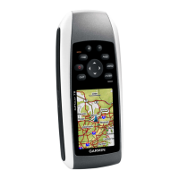
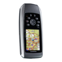
Garmin GPSMAP 78 series Specifications

General IconGeneral
Display Resolution160 x 240 pixels
Weight7.7 oz (218 g) with batteries
Battery Type2 AA batteries (not included); NiMH or Lithium recommended
Water RatingIPX7
High-Sensitivity ReceiverYes
InterfaceUSB
Built-in Memory1.7 GB
Waypoints2000
Routes200
Track Log10, 000 points, 200 saved tracks
Physical Dimensions2.6" x 6.0" x 1.2" (6.6 x 15.2 x 3.0 cm)
Memory ExpansionmicroSD™ card (not included)
Display Size2.6 inches
Battery Life20 hours
Display TypeTFT color
Battery RecommendationNiMH or Lithium
Preloaded MapsBasemap

Related product manuals