Do you have a question about the Parrot ANAFI Ai and is the answer not in the manual?
Details the design and capabilities of the ANAFI Ai drone, emphasizing its out-of-the-box usability.
Defines the ANAFI Ai ecosystem as the drone, controller, and FreeFlight 7 flying app.
Advises on switching off smartphone Wi-Fi to avoid interference with the drone's network.
Explains ANAFI Ai's GPS capabilities and the Skycontroller 4's lack of geo-positioning.
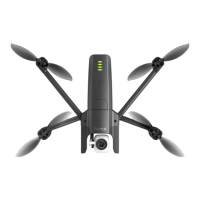
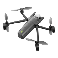
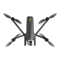
Details the physical dimensions, weight, performance, and features of the ANAFI Ai drone.
Outlines the dimensions, weight, connectivity, and features of the Parrot Skycontroller 4.
Provides technical details on the ANAFI Ai's camera sensor, lens, and imaging capabilities.
Identifies key components of the ANAFI Ai drone for flight preparation.
Guides users through the process of activating the nano SIM card for 4G functionality.
Explains the default anonymous data sharing option for product improvement.
Describes the Private mode, which deletes all flight data from the device.
Details how to create and use a Parrot.Cloud account for data backup and support.
Provides guidance on using obstacle avoidance assistance during manual drone control.
Explains how to calibrate the Skycontroller 4's magnetometer for optimal performance.
Details the steps for performing a precise gimbal calibration on the ANAFI Ai.
Guides users through calibrating the drone's magnetometer for accurate navigation.
Outlines the process for calibrating the drone's obstacle avoidance system.
Provides essential guidelines for safely transporting and handling the ANAFI Ai drone.
Lists important flight conditions and regulations to ensure safe drone operation.
Details the steps for initiating a ground take-off for the ANAFI Ai drone.
Explains the Pilot advanced RTH mode, returning to the device's GPS position.
Provides instructions and warnings for performing a safe hand landing.
Details how to charge the ANAFI Ai's smart LiPo battery using USB-C.
Offers essential advice on handling, storing, and maintaining the smart battery.
Guides users on transferring photos and videos from the drone to a computer.
Explains how to format the microSD card using the FreeFlight 7 Gallery.
Describes the heads-up display (HUD) interface of the FreeFlight 7 application.
Overview of the Quick settings tab with options like Map, Audio, and Auto-record.
Details how to manage the controller's behavior and input settings.
Allows users to customize flight behavior for Film and Sport modes via sliders.
Options for map type, measurement system, and grid overlay in the interface.
Enables setting height and distance limits for the Geocage feature.
Defines the drone's behavior when the Return To Home (RTH) feature is activated.
Allows selection of camera options for photo and video recording modes.
Manages 4G connection, Wi-Fi network name, password, and DRI broadcast.
Guides on selecting video resolution, framerate, and other filming settings.
Explains different photo modes like Timelapse, GPS Lapse, Panorama, Bracketing, and Burst.
Details the process of capturing and generating panoramas using the drone.
Explains how to use the left trigger to control the gimbal's vertical tilt.
Details using the right trigger for zoom functionality in video and photo modes.
Guides on adjusting the EV scale to control the overall brightness of images/videos.
Explains how to manually set shutter speed, affecting exposure time.
Details how to adjust ISO sensitivity for optimal performance in varying light conditions.
Guides on setting white balance to ensure accurate color representation in footage.
Explains how to lock exposure on a specific frame or detail using touch input.
Introduces photogrammetry and its use with PIX4D technologies for mapping.
Details programming and executing simple grid flights for 2D map creation.
Explains how to create 3D maps or models using double grid photogrammetry flights.
Guides on programming circular mapping flights for 3D modeling of structures.
Describes the simplified 1-Click mission for creating 3D models of single buildings.
Presents a use case scenario for automated flight and filming management.
Guides on setting POIs for automated flights, defining altitude and camera aim.
Details how to create and manage waypoints for precise flight path programming.
Configures image settings like resolution, framerate, and exposure for Flight Plans.
Sets flight parameters such as obstacle avoidance and RTH behavior for Flight Plans.
Instructions on launching and monitoring an automated flight plan.
Guides on setting up ANAFI Ai for take-off from a moving vehicle.
Explains the RTV feature to return the drone to its take-off vehicle.
Provides crucial safety advice for landing a drone on a moving vehicle.
Enables flying the drone to any point on the map by selecting a destination.
Allows flying the drone around a selected point while keeping it centered.
Displays recorded flights, distance flown, and flight time from the dashboard.
Access and manage saved Flight Plans and Photogrammetry projects.
Step-by-step guide for replacing ANAFI Ai propeller blades.
Procedure for powering off and restarting the drone, controller, and device.
Restores the drone to its latest firmware update, clearing data.
Reverts the controller to its latest firmware update, clearing logs and credentials.
Identifies common causes of 4G connectivity problems and how to resolve them.
Verifies that software and calibrations are up-to-date and operational.
Checklist items for the drone and controller when powered off.
Checklist items for the drone and controller when powered on.
Ensures all pre-flight checks are completed before taking off.
| Camera Sensor | 1/2" CMOS |
|---|---|
| Camera Resolution | 48 MP |
| Video Resolution | 4K HDR |
| Flight Time | 32 minutes |
| Weight | 898 g (1.98 lbs) |
| Aircraft Type | Quadcopter |
| Operating Temperature | -10°C to 40°C (14°F to 104°F) |
| GNSS Support | GPS, GLONASS, Galileo |
| Maximum Video Resolution | 4K HDR at 30fps |
| Video Recording Modes | 4K HDR, 4K |
| Photo Format | JPEG, DNG |
| Gimbal | 3-axis |
| Operating Frequency | 2.4 GHz |
| Connectivity | USB-C |
| Field of View | 84° |
| Bluetooth | Yes |