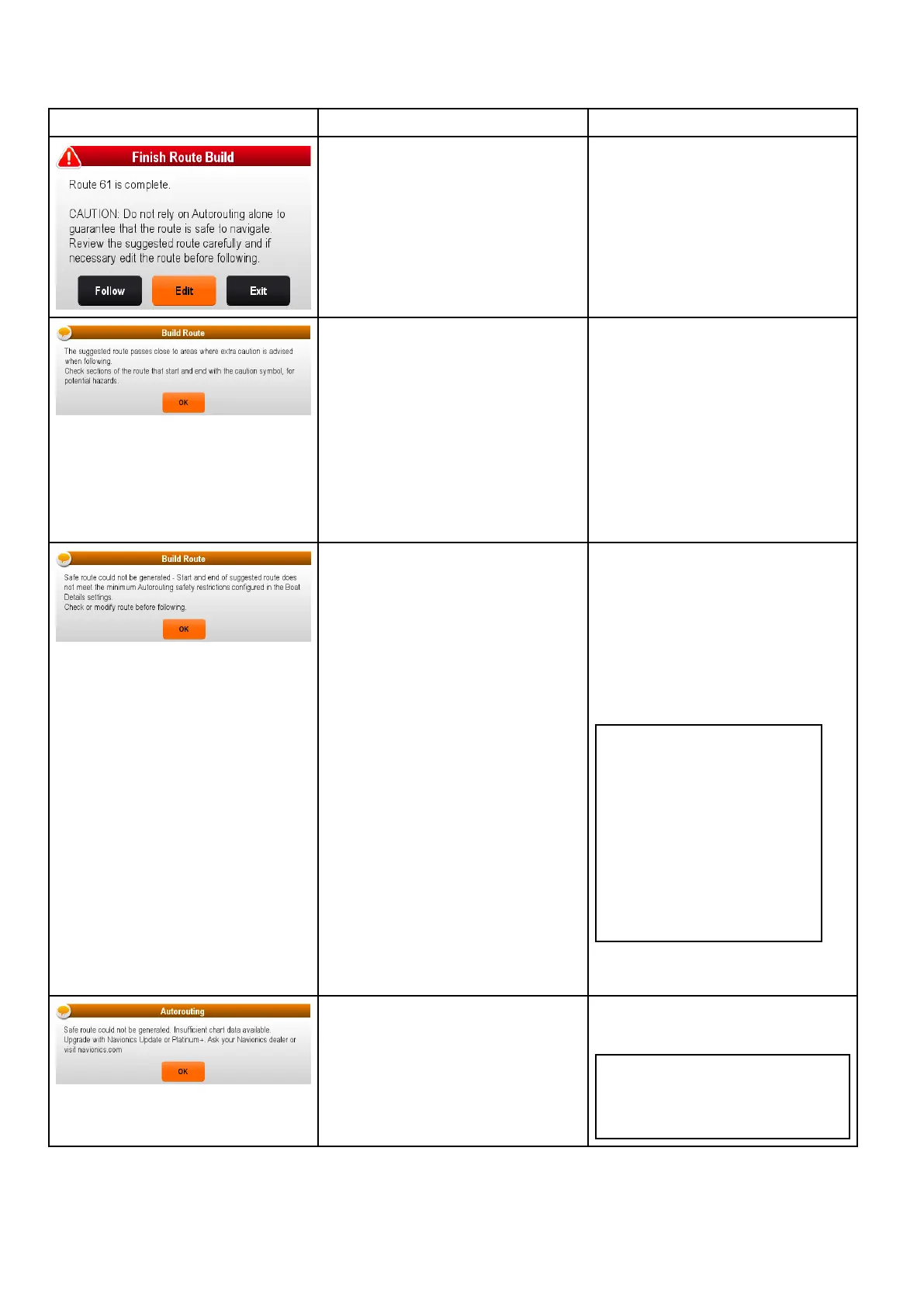
26.5Troubleshootingautomaticroutegeneration
Theinformationbelowdetailsthewarningsthatcanbedisplayedwhenusingautomaticroutegeneration,a
descriptionofwhatthewarningmeansandactionstobetakentocorrecttheissue.
ExamplewarningmessageDescriptionResolution
RoutegenerationcompletedsuccessfullyTheRoutemaybefollowedAFTERit
hasbeenreviewedtoensurethatthe
generatedrouteissafeforyourvessel
tofollow.
Routegenerationcompletedsuccessfully,
howevertheroutepassesclosetoareas
whereextracautionisadvised(e.g.a
chartedbuoy).
Thecautionareaswillbebetween
waypointsthathavebeenassigned
cautionsymbol.
Theroutemustbereviewedasfollows:
•Identifyanywaypointsusingthe
cautionsymbol(thesewillbeinsetsof
2),checkbetweenthecautionsymbols
toidentifythereasonforthecaution.
•Ifpossiblemovethewaypoint(s)to
avoidthehazard.
•Reviewallroutelegsandtheir
waypointstoensureappropriate
beforefollowingtheroute.
Thestartandorendpointoftheroute
doesnotmeettheminimumsafevalues
speciedintheBoatDetailssettings.
Thestartandendwaypointswillbe
createdandjoinedwithastraight
routeleg,howevertherewillbeno
automaticallygeneratedwaypointsand
thewaypointsymbolswillbechangedto
cautionsymbols.
Performthefollowingchecks:
•Checkthatthevaluesspeciedinthe
BoatDetailssettingsarecorrect.
•Usingthecontextmenucheckthe
ChartObjectsmenuattheexact
locationofthestartandorendpoints
toestablishiftheDepthrangemeets
yourMinimumSafeDepth.
Note:
–Ifnominimumvaluefordepth
isavailableatthedesired
location,aminimumdepthof0
feetisassumed.
–Automaticroutegeneration
addsitsownsafetymarginof
0.8mor20%ofthespecied
MinimumSafesettings.which
everisgreater.
•Checkforanyotherhazardsthat
wouldpreventroutegeneration.
Thereisinsufcientdataavailableonthe
cartographytogeneratetheroute,
Thestartandendwaypointswillbe
created,howevertherewillbeno
automaticallygeneratedwaypointsand
thewaypointsymbolswillbechangedto
cautionsymbols.
•Insertcompatiblecartography
•Updateexistingcartography
Note:Theremaybecertainareas
wheresufcientdetailsarenot
yetavailableevenonthelatest
cartography.
350
LightHouseMFDoperationinstructions

 Loading...