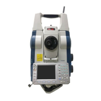
Do you have a question about the Sokkia SRX3 and is the answer not in the manual?
Procedure for centering the instrument on the tripod for stable measurement.
Instructions for levelling the instrument using the screen and foot screws.
Configuration of Auto Pointing functions including accuracy and search methods.
Procedure for using the Auto-Pointing function to automatically sight targets.
Settings for Auto Tracking functions, including configuration and search settings.
Procedure for performing measurements using the Auto Tracking function.
Procedure to measure the included angle between two points by setting the horizontal angle to 0°.
How to reset the horizontal angle to a specific value for new target measurements.
Steps to enter instrument station coordinates, instrument height, and target height.
Finding 3D coordinates of a target using station data and measurements.
Determining instrument station coordinates by measuring known points.
Determining instrument station elevation (Z) by measuring known points.
How the guide light indicates SRX status and helps reposition the target.
Procedure for setting out points based on distance from the instrument station.
Setting out required coordinate locations using calculated angles and distances.
Performing setting-out measurements for points where targets cannot be directly installed.
Measuring slope, horizontal distance, and angle to targets without moving the instrument.
Customizing softkey allocations in Meas mode for efficient operation.
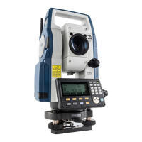
| Type | Robotic Total Station |
|---|---|
| Laser Class | Class 3R |
| Operating Temperature | -20°C to +50°C |
| Reflectorless Range | 0.3 to 1, 000 m (Kodak Gray Card 90% reflective) |
| Measurement Range (without prism) | 0.3 to 1, 000 m (Kodak Gray Card 90% reflective) |
| Wireless Communication | Bluetooth |