Do you have a question about the Standard Horizon GX2400GP and is the answer not in the manual?
Explains VHF radio frequencies and transmission range for marine communication.
Guides users on choosing the appropriate marine VHF antenna based on gain and type.
Details selection and types of coaxial cable for connecting VHF antennas.
Provides the procedure for making a Mayday distress call on Channel 16.
Outlines the process for initial contact and channel switching with other vessels.
Explains the typical reception range for AIS (Automatic Identification System) receivers.
Details the expected accuracy of the Course Over Ground (COG) output.
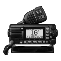
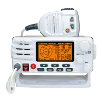
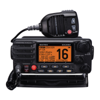
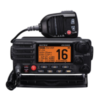
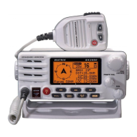
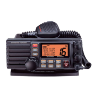
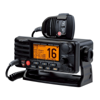
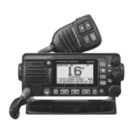
Identifies and explains all controls and indicators on the transceiver's front panel.
Details the functions and controls of the handheld microphone unit.
Describes the various connectors and ports located on the rear of the transceiver.
Crucial safety and warning information related to radio installation and operation.
Guidelines for choosing an optimal and interference-free mounting location for the radio.
Instructions for securely mounting the transceiver using the supplied bracket.
Procedure for installing the optional flush-mount bracket for a clean installation.
Details power and antenna connections, including fuse replacement procedures.
Covers connecting various external devices like GPS, AIS, and speakers.
Wiring instructions for connecting the internal GPS output to a chart plotter.
Guidance on connecting external GPS receivers or chart plotters.
Wiring diagram for connecting an optional PA/HAIL speaker system.
Steps for connecting the optional SCU-38 external GPS antenna.
Instructions for connecting the optional SCU-31 external GPS antenna.
Details the connection and installation of the optional SSM-70H remote microphone.
Instructions for installing the SCU-30 wireless access point for remote microphones.
Guide to programming the Maritime Mobile Service Identity (MMSI) for DSC operation.
How to set the transceiver's internal clock using time offset for local time.
Configures the transceiver to display UTC or local time based on selected time zones.
Allows selection between 12-hour and 24-hour time display formats.
Enables display of Course Over Ground (COG) using true or magnetic variation.
Step-by-step instructions for powering the radio on and off.
How to set up the radio to receive signals by adjusting volume and squelch.
Guide to transmitting voice communications using the PTT switch and microphone.
How to switch between high (25W) and low (1W) transmit power levels.
Explains how to navigate and customize transceiver settings using the setup menu.
Details the function of the TOT to prevent continuous transmission.
Information on using simplex and duplex channels for communication.
How to select the appropriate channel group based on region (USA, INTL, CAN).
Instructions for accessing and listening to NOAA weather broadcasts.
How to receive and respond to NOAA weather alert tones and broadcasts.
Procedure for testing the NOAA weather alert system functionality.
How to set up and use Dual Watch and Triple Watch features.
Explains how to program and operate memory and priority scanning modes.
Details how to perform memory scanning to monitor programmed channels.
Describes how to perform priority scanning, including the priority channel.
How to program and access up to 10 preset channels for quick selection.
Steps to remove channels from the preset channel memory.
Functionality to memorize position information instantly in case of Man Over-Board.
How to use the 30W hailer for PA and foghorn signaling.
Steps for using the PA HAIL mode for two-way communication.
How to select and operate various fog horn signals (Underway, Stop, etc.).
A chart illustrating fog signal patterns and their corresponding usage.
How to establish intercom communication between the transceiver and remote microphones.
Procedure for initiating and conducting voice communication via intercom.
How to signal another station using the intercom calling function.
Information on the voice scrambler function, requiring dealer activation.
How to enter and operate the demonstration mode for sales and dealer presentations.
How to view current position data in numerical and compass formats.
Shows detailed numerical latitude, longitude, and time data.
Displays position information with a compass rose for directional reference.
How to verify the status of the GPS receiver and satellite signal acquisition.
Details on using the built-in logger to record position information at intervals.
Overview of DSC technology, its purpose, and maritime applications.
Explains the transceiver's capability to send and receive DSC distress messages.
Step-by-step guide to initiating a DSC distress call with position data.
How to specify the nature of distress when sending an alert.
Procedure to manually input location and time for distress alerts when GPS is unavailable.
How to temporarily suspend or resume the retransmission of a distress alert.
Instructions for sending a message to cancel a previously transmitted distress alert.
How to respond to an incoming DSC distress alert and navigate to the distressed vessel.
Functionality for contacting all DSC-equipped vessels with safety or urgency messages.
Guide to sending safety or urgency calls to all ships.
How to handle incoming All Ships calls and switch to the appropriate channel.
Enables direct contact with other vessels using their MMSI number.
How to program vessel names and MMSI numbers into the directory for individual calls.
| Type | Fixed Mount VHF Marine Transceiver |
|---|---|
| NMEA Connectivity | NMEA0183 and NMEA2000 |
| Modulation | FM |
| Power Supply | 13.8V DC |
| Backlight | Yes |
| Power Output | 25W |
| Channels | USA, International, and Canadian |
| DSC | Yes (Class D) |
| Dimensions | 160 W |
| Waterproof Rating | IPX8 |
| AIS | Yes |
| GPS | Integrated 66 Channel WAAS GPS Receiver |