Do you have a question about the TomTom Rider 400 and is the answer not in the manual?
Details new features and version information for the TomTom Rider.
Provides links to helpful videos for learning about the TomTom Rider and related products.
Instructions for attaching the RAM mount kit to a motorcycle and connecting wires.
Explains how to use the two-part anti-theft lock system for the device and mount.
Steps for installing the TomTom Rider using the car mount kit.
Guides on connecting the Rider to a smartphone and headset via Bluetooth.
How to change the device's Bluetooth name for easier identification.
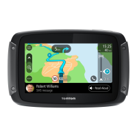
Detailed steps for connecting a Bluetooth headset for audio feedback.
Describes the function of various navigation buttons available in the Main Menu.
Explains how to use the keyboard with gloves on, including special key functions.
How to create interesting rides with custom turns and hilliness settings.
How to view detailed statistics about rides, including distance, time, and speed.
Describes how to use quick settings for easy adjustments while wearing gloves.
Steps to get free access to Tyre Pro for route creation and editing.
Guidelines for safely and effectively positioning the device in a vehicle.
Procedures for powering the device on, putting it to sleep, and turning it off.
Initial setup process involving answering questions to configure the device.
Information about how the device acquires GPS signals and improves reception.
How to manage data sharing preferences with TomTom for service improvement.
Information on using a memory card for extra storage like maps or routes.
Troubleshooting steps for when the device fails to start or respond.
How to charge the device's battery using various power sources.
Explains real-time information services like traffic and safety cameras.
How the MyDrive app connects the Rider to the internet via smartphone.
Steps to launch the MyDrive app and initiate service connection.
Information on data sharing for TomTom services and user consent.
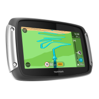
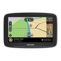
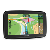
Explanation of the map view interface, navigation, and interactive elements.
Description of the guidance view for turn-by-turn navigation and its features.
Details about the route bar, including arrival information and symbols.
Accessing and using the quick menu for common actions.
Information about TomTom's real-time traffic service and its benefits.
How traffic incidents are visualized on the map interface.
Explanation of various traffic incident symbols and their meanings.
Steps to reroute the journey to avoid traffic jams.
Feature providing lane guidance for highway exits and junctions.
Introduction to MyDrive for managing destinations, locations, and personal info.
Instructions for logging into MyDrive on the Rider or via web/app.
How to send destinations from MyDrive to the Rider.
How to find and sync locations between MyDrive and My Places.
Compares Quick search and Step-by-step search methods.
Detailed guide on using the quick search functionality.
How to interpret and interact with search results.
Using ZIP codes for location searching.
Using mapcodes for location identification.
Visual guide to icons representing different Points of Interest categories.
Explains Quick Search vs. Step-by-step search options.
Guide to performing searches using the step-by-step method.
How to manage and utilize search results from step-by-step searches.
Using ZIP codes within the step-by-step search process.
Creating routes using the quick search feature.
Steps to plan a route to a specific address via search.
Steps to plan a route to a city center via search.
Steps to plan a route to a Point of Interest via search.
Creating routes by selecting locations directly on the map.
Navigating to saved locations like Home or Work.
Steps to plan a route using latitude and longitude coordinates.
Steps to plan a route using a mapcode.
How to plan and save routes before driving.
Steps to locate parking lots near a destination or current location.
Steps to locate gas stations along a route or near the current location.
Overview of options available in the Current Route menu.
Steps to reroute the journey to bypass blocked roads.
How to find and select alternative routes.
Different route planning options like fastest, shortest, or winding.
Options to avoid specific road features like tolls or ferries.
Introduction to saving and retrieving routes and tracks.
Steps to save a planned route to My Routes.
How to select and follow a previously saved route.
Steps to record a driving track.
How to navigate along an imported track.
Steps to import routes from a computer via USB.
Overview of the Safety Cameras service and types of alerts.
How the device provides warnings for approaching safety cameras.
How to report new safety cameras encountered while driving.
Options to customize the device's visual display settings.
Options for selecting and configuring voice prompts for navigation.
Settings for language, country, keyboards, units, and time/date.
System settings including device information and resets.
Accessing a tutorial for using the navigation device.
Refers to System information for device details.
How to find certification numbers and regulatory information on the device.
Introduction to the desktop application for managing the Rider.
Requirement and creation process for a TomTom account.
Initial setup steps for the MyDrive Connect software.
Critical safety information, including GPS, driving care, and vehicle restrictions.
Locations where device use is prohibited and legal driving restrictions.
Information on battery care, operating temperatures, and warnings.
FCC compliance statement regarding radio frequency energy.
Compliance with government requirements for radio wave exposure.
Compliance with IC radiation exposure limits for uncontrolled environments.
Information on data usage, warranty, and software licenses.
Lists the items included in the device package.
Disclaimer regarding document accuracy and copyright.
| Marine (chartplotters, sounders) | No |
|---|---|
| Live service | - |
| Languages support | BUL, CZE, DAN, DEU, DUT, ENG, ESP, EST, FIN, FRE, GRE, HUN, ITA, LAV, LIT, NOR, POL, POR, SLK, SLV, SWE, TUR |
| Map coverage | All Europe |
| Display diagonal | 4.3 \ |
| Display resolution | 480 x 272 pixels |
| Placement supported | Horizontal/Vertical |
| Storage media type | Flash |
| Compatible memory cards | MicroSD (TransFlash) |
| Internal storage capacity | 16 GB |
| Form factor | Fixed |
| Product color | Black, Silver |
| International Protection (IP) code | IPX7 |
| Power source type | Battery, DC |
| Battery life (max) | 6 h |
| Cables included | USB |
| QuickGPSfix | QuickGPSfix speeds up the time it takes to fix your GPS position to help you get on the road more quickly. |
| TomTom Traffic | Get the most up-to-date, real-time traffic information for your route live on your TomTom device. Includes detailed incident reports, estimated delay times and alternative route proposals. |
| Depth | 30.5 mm |
|---|---|
| Width | 136.8 mm |
| Height | 88.4 mm |
| Weight | 280 g |