Do you have a question about the ComNav Technology Sino GNSS N5 and is the answer not in the manual?
Before using the receiver, ensure you read and understand this User Guide and safety requirements.
Alerts you to potential risks of injury or equipment damage due to improper operations or settings.
General overview of the N5 GNSS receiver and its capabilities in harsh environments.
Lists the key features of the SinoGNSS N5 GNSS Receiver, including size, weight, and technologies.
Details the included parts for the N5 receiver, covering basic supplies and optional kits.
Specifies the ideal environmental conditions for operating the N5 GNSS receiver to ensure reliable performance.
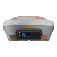
Describes front panel components and lower housing details like ports and compartments.
Covers both internal batteries and external power input options for the N5 GNSS receiver.
Explains the use, charging, and safety precautions for the receiver's rechargeable Lithium-ion batteries.
Details how to connect and use an external power supply, including correct connection of alligator clips.
Explains the procedure for charging the receiver's batteries using the N5 receiver itself as a charger.
Illustrates the correct procedure for mounting the receiver onto a range pole for field use.
Describes the three interfaces on the OLED display used for status, work mode, and basic settings.
Explains the functions of receiver buttons and the meaning of LED status indicators.
Guides on connecting to and using the receiver's web-based graphical user interface for configuration.
Details how to configure the receiver using the Compass Receiver Utility (CRU) software for static surveys.
Provides guidelines for performing static surveys to achieve millimeter accuracy, including setup and data recording.
Explains how to download raw observation data from the receiver's internal memory using a USB cable.
Describes the process of converting ComNav binary data (*.cnb) to RINEX format using CRU software.
Guides on downloading and installing the Survey Master software on the SinoGNSS controller.
Explains how to use the Survey Master wizard for a quick start and learning the general workflow.
Details how to create a new project in Survey Master, including datum selection and sharing options.
Provides steps to establish a Bluetooth connection between the Survey Master and the N5 receiver.
Guides on setting up the N5 receiver as a base station using internal radio mode in Survey Master.
Explains how to configure the N5 receiver as a rover station, matching base settings for RTK.
Details setting up the N5 receiver for RTK using external radio for extended working distance.
Guides RTK survey using CORS correction data received via PDA's GPRS or Wi-Fi.
Covers Point to Point/Points and Ntrip client modes for RTK using internal GPRS.
Details the Point to Point/Points mode for RTK correction data transmission using SIM cards.
Explains how the rover acquires correction data from Ntrip (CORS) servers using internal 4G.
Covers the Topo survey function, including starting, stopping, and checking coordinates.
Configures various survey parameters like fixed results, duplicate names, and occupation time.
Explains the bubble setting for tilt survey, utilizing the IMU sensor for precise measurements.
Describes Auto and Area survey functions for continuous measurement and area calculation.
Details how to stake points and lines, including navigation and alarms based on proximity.
Explains PPK for dynamic measurements, requiring base and rover receivers for static data recording.
Covers site calibration, a necessary step for establishing a calibrated datum system for a project.
Details the grid shift function for changing the base station position within an existing project.
Explains Coordinate Geometry functions for calculating points, lines, and angles directly in the field.
Guides on importing data, including grid coordinates and DXF/DWG files, with support for various file formats.
Explains how to export survey points and results in various formats like CSV, DXF, and KML.
Describes importing DXF/DWG/SHP files as a basemap in Survey Master for enhanced visualization.
Explains how to configure NMEA 0183 data output via the lemo port or Bluetooth.
Guides on registering the N5 receiver using its unique code through the Survey Master software.
Details the steps for connecting the receiver to a PC and updating its firmware using the provided software.
Provides a diagram and description of the 7-pin Lemo connector and its pin assignments.
Lists the physical parameters and specifications for the radio and Bluetooth modules within the N5 receiver.
Outlines FCC compliance statements, warnings, and radiation exposure limits for the device.
| Brand | ComNav Technology |
|---|---|
| Model | Sino GNSS N5 |
| Category | Receiver |
| Language | English |