6 Static Surveying
A20 also has static surveying function, which includes outdoors surveying and office
6.1 Process
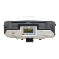
1) Fix A20 on tripod.
2) Measure the height of A20.
3) Turn on A20 while more than 4 satellites are tracked by this instrument, then start the
static surveying from the buttons of A20 screen.
4) It is important to record the surveying time, SN of A20,height of A20, etc. on a notebook
5) When outdoors surveying is over, turn off A20.
Notice:
Normally, it is better to record the static data on SD card.
6.2 Data Downloading and Format Converting
1) Connecting A20 and PC for data downloading.
2) File name given should according to the notes of outdoors surveying made by yourself.
SN of A20, surveying time and point name should all be indicated in the file name for
your easy distinction. For example, A20, the detailed information is,A200000086(SN
A20 User Manual
35
while this receiver is doing the static surveying.
working.