Do you have a question about the Foif A20 and is the answer not in the manual?
Covers regulations and safety guidelines for receiver usage.
Precautions for safe exposure to radio frequency radiation.
Safety considerations for the internal Bluetooth wireless radio.
Guidelines and warnings for handling rechargeable lithium-ion batteries.
Warnings regarding operating or storing the receiver outside specified temperature ranges.
Lists components included in the base transport container.
Details the accessories and components found in the rover transport container.
Procedure for setting up the GNSS base station in an open environment.
Instructions for setting up the base station using an external radio module.
Description of the front and back panels of the external radio unit.
Explains how the power amplifier extends transfer distance and its compatibility.
Procedure for setting up the GNSS rover station on a pole.
Methods for measuring antenna heights for tripod setups.
Details on measuring antenna height when using a pole setup.
Describes connecting the controller via Bluetooth or RS232.
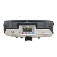
Identifies various parts of the A20 GNSS receiver's frontal panel.
Identifies various parts of the A20 GNSS receiver's bottom panel.
Details the OLED screen and physical buttons on the receiver.
Describes the ways battery power is supplied to the A20 receiver.
Instructions for turning the receiver on and off using the power button.
Details the functions of the hot button for starting various survey modes.
Explains the function of the Esc and Enter buttons for navigation and confirmation.
Explains the function of the Up and Down buttons for menu navigation.
Describes the meaning of the Battery, Satellite, Link, and Record LED indicators.
Shows the initial startup screen of the A20 GNSS receiver.
Explains the elements displayed on the A20's main interface.
Details the Info menu options including GNSS, Coordinate, and satellite quality.
Details the Info menu options for Radio, GPRS, Memory, and Battery.
Details the About menu and Set menu options for GPS, Link, Memory, System.
Details Set/GPS/Base options for format, linker, and position settings.
Details Set/GPS/Rover and Set/GPS/Static options.
Details Set/Link/GPRS, Set/Link/Radio, and Set/Memory options.
Details Set/Memory/Flash, Set/Memory/SD card, and Set/System options.
Details Set/System/Bluetooth, Set/System/Voice, and Set/System/Language.
Details Set/System/Screen/Contrast and Set/System/Screen/OLED options.
Step-by-step guide for performing static surveying with the A20 receiver.
Instructions for downloading data and converting it to RINEX format.
Guidance for conducting static surveying in outdoor environments.
Guidelines for designing a reliable and accurate GPS network.
Details accuracy standards and levels for static surveying.
Describes different GPS network designs like Tracking, Multi-base, and Single-base.
Explains different network shapes like Radial network.
Details Point connecting and Side connecting network shapes.
Covers Polygon, Mixed networks and general principles for GPS network design.
Details point position, reliability, and precision considerations for GPS network design.
Details the physical characteristics such as size, weight, and environmental resistance.
Provides accuracy specifications for postprocessing and real-time positioning.
Lists technical features like tracking channels, communication, and memory.
Details the specifications of the Getac PS236 controller.
Details the specifications of the optional Getac PS535E controller.
| Channels | 220 |
|---|---|
| Tilt Sensor | Yes |
| IMU | Yes |
| Battery Life | Up to 10 hours |
| Waterproof/Dustproof | IP67 |
| Satellite Systems | Galileo |
| Data Storage | Internal memory |
| Communication | Bluetooth, Wi-Fi |
| Power Supply | Rechargeable battery |
| Antenna Type | Internal |
| Interface | USB |
| Protocol | NMEA |