EasyManua.ls Logo

Furuno GP-37 User Manual

Furuno GP-37
2 pages
To Next Page IconTo Next Page
Page #1 background imageLoading...
Page #1 background image
DGPS NAVIGATOR GP-37
GPS NAVIGATOR GP-32
Operator’s Guide
The purpose of this Operator's Guide is to provide basic operating procedures for this
equipment. For more detailed information see the Operator's Manual.
Choosing Display Mode
Press the [DISP] key until desired display
appears.
[Highway Display]
COG
BRG
RNG
SOG
0.5
XTE
0.05
242°
0.05 0.05
17.5
004
n
m
[Plotter Display]
D2D
[ 5 ]
n
m
SOG:
10.0
k
t
34°44.000N 135°21.000E
X
D2D MAG 15:37
NE
30 60
300 330
SOG:
kt
COG:
RNG:
BRG:
TTG:
ETA:
1H30M 12:30
17.5 nm
242°
[Steering Display]
(Display format
depends on user setting.)
CURSOR
[+]
n
m
k
t
[Nav Data Display]
D2D
02-FEB-02 15:37:40
SOG:
kt
CSE:
34°44. 000'
N
135°21. 000'
E
10.0 357°
COG:
357°
357°
10.0
10.0
357
°
[User Display: Speedometer]
(Display format
depends on user setting.)
20
30
40
60
0
10
0
9.9
KT
SOG
[User Display: Digital Data]
POWER(V) SOG(KT)
TRIP(NM) COG(°)
9.99 5.6
12.1 9.9
[DISP] key
[DISP] key
[DISP] key
[DISP] key
[DISP] key
[DISP] key
Choosing Display Range
1. Press the [MENU] key.
2. Press the [ENT] key.
3. Press
!
to increase;
"
to decrease.
4. Press the [ENT] key to close the window.
Shifting the Cursor, Display
1. On the plotter display, press the cursor
pad to turn on the cursor. Use the cursor
pad to shift the cursor.
2. Place the cursor on an edge of the screen.
Use the cursor pad to shift the display.
Centering Own Position
1. Press the [MENU] key.
2. Choose “SHIP TO CENTER?”.
3. Press the [ENT] key.
Entering MOB Mark
1. Press the [MARK/MOB] key several
seconds.
2. Choose YES.
3. Press the [ENT] key.
Question and Answer IconNeed help?

Do you have a question about the Furuno GP-37 and is the answer not in the manual?

Furuno GP-37 Specifications

General IconGeneral
TypeGPS Navigator
Display Size4.5 inches
Display Resolution240 x 128 pixels
Waypoints1000
Routes50
InterfaceNMEA 0183
Power Supply12-24 V DC
Receiver Type12-channel
Accuracy10 m
DisplayLCD
Display TypeLCD
Track Points10000

Summary

Choosing Display Mode

User Display: Speedometer

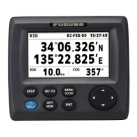
Displays speed, SOG, COG, and navigation data using the DISP key.

Plotter Display

Shows track and navigation data on a chart format.

User Display: Digital Data

Presents power, SOG, trip, and COG in a digital format.

Highway Display

Illustrates bearing, range, SOG, and XTE for navigation.

Nav Data Display

Shows date, time, position, SOG, COG, and ETA.

Steering Display

Provides heading, course, and bearing information for steering.

Shifting the Cursor, Display

Centering Own Position

Entering MOB Mark

Choosing Display Range

Registering Waypoints

Registering Routes

Setting, Cancelling Destination

To set destination by cursor

Procedure to set a destination using the cursor on the screen.

To cancel destination

Method to cancel the currently set destination.
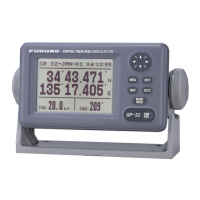
Setting the Arrival Alarm

Related product manuals