EasyManua.ls Logo

Furuno BACK GP-80 User Manual

Furuno BACK GP-80
103 pages
To Next Page IconTo Next Page
Page #1 background imageLoading...
Page #1 background image

Table of Contents

Questions and Answers:

Furuno BACK GP-80 Specifications

General IconGeneral
BrandFuruno
ModelBACK GP-80
CategoryGPS
LanguageEnglish

Summary

SAFETY INSTRUCTIONS

DANGER

Defines a potentially hazardous situation leading to death or serious injury.

WARNING

Defines a potentially hazardous situation leading to death or serious injury.

CAUTION

Defines a potentially hazardous situation leading to minor injury or property damage.

SAFETY INFORMATION FOR THE OPERATOR

WARNING Label attached

Details the attached warning label and its implications for safe operation.

FOREWORD

SYSTEM OVERVIEW

1. Menu Tree

Illustrates the hierarchical structure of the system's menu options.

3. Operation Flow Chart

1. OPERATIONAL OVERVIEW

1.1 Control Description

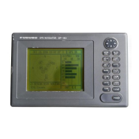
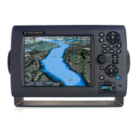
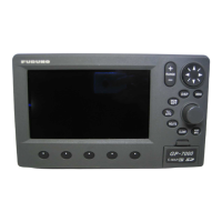
Describes the function of each button on the GP-80 control panel.

1.2 Turning On and Off the Power

1.3 Adjusting Display Contrast and Brilliance

1.4 Selecting the Display Mode

Navigation display

1.5 Chart Icons

2. TRACK

2.1 Enlarging/Shrinking the Display

Explains how to adjust the zoom level on plotter displays for better viewing.

2.2 Selecting Display Orientation

Details how to choose between North-up and Course-up display orientations.

2.3 Shifting the Cursor

Describes how to move the cursor on the display using the cursor keys.

2.4 Shifting the Display

2.5 Centering Cursor Position

2.6 Centering Own Ship's Position

2.7 Stopping/Starting Plotting and Recording of Track

2.8 Erasing Track

2.9 Selecting Track Plotting Interval

2.10 Apportioning the Memory

2.11 Selecting Bearing Reference

3. MARKS

3.1 Entering/Erasing Marks

Covers the process of adding and removing waypoints or event marks on the display.

3.2 Selecting Mark Shape

3.3 Connecting Marks (selecting mark connection line)

3.4 Entering Event Marks

3.5 Selecting Event Mark Shape

3.6 Entering the MOB Mark

4. NAVIGATION PLANNING

4.1 Registering Waypoints

Explains how to save specific locations on the chart as waypoints for navigation.

4.2 Editing Waypoints

4.3 Deleting Waypoints

4.4 Registering Routes

4.6 Replacing Route Waypoints

4.7 Deleting Routes

5. STARTING FOR DESTINATION

5.1 Setting Destination

Details the methods for selecting a destination waypoint or route for navigation.

Setting route as destination

5.2 Cancelling Destination

5.3 Erasing Route Waypoints (flags)

5.4 Finding Range and Bearing Between Two Points

6. SETTING UP VARIOUS DISPLAYS

6.1 Selecting Data to Display on the Data Display

Guides users on choosing data fields for the multi-window data display.

6.2 Selecting Position Format

6.3 Demo Display

7. ALARMS

7.1 Arrival Alarm, Anchor Watch Alarm

Explains how to set and manage alarms for arrival at a destination or anchor watch.

7.2 Cross Track Error (XTE) Alarm

7.3 Ship’s Speed Alarm

7.4 Trip Alarm

7.5 Water Temperature Alarm

7.6 Depth Alarm

7.7 DGPS Alarm

8. MENU SETTINGS

8.1 GPS Menu

Covers GPS receiver settings including fix mode, satellite status, and smoothing.

Selecting fix mode

Disabling satellites

Entering GPS position smoothing

Entering GPS speed smoothing

Entering speed averaging

Entering geodetic datum

Entering position offset

Entering time difference

Entering position

8.2 Selecting Units of Measurement

Unit of water temperature

Unit of altitude

8.3 Mark, Character Size and Brilliance

Grid tone

Course bar tone

Time mark tone

Waypoint mark size

Cursor size

Enlarging characters

8.4 Settings for Connection of Navigator

DATA 1 output setting

Configures data output format and interval for NMEA 0183 and IEC 61162-1.

DATA 2 output setting

DATA 3 output setting

Setting DATA 4 to NMEA

8.5 Receiving Data from Personal Computer

Loading Waypoints/Routes data

Instructions for downloading waypoint and route data from a PC via the DATA 4 connector.

Loading waypoint data from YEOMAN equipment

Saving data to personal computer

Stopping loading of data

8.6 DGPS Settings

Selecting DGPS station

Details automatic and manual configuration for receiving DGPS beacon signals.

Setup for external DGPS beacon receiver

8.7 Displaying GPS Monitor Displays

9. MAINTENANCE & TROUBLESHOOTING

9.1 Clearing the Memory

Procedures for clearing plotter and GPS memory, or both, to reset settings.

9.2 Preventative Maintenance

9.3 Error Messages

9.4 Troubleshooting

9.5 Self Tests

Memory and I/O circuits test

Describes how to perform self-tests on memory and input/output circuits.

Keyboard test

Guides users through testing the functionality of each key on the control panel.

Display test

Automatic testing

10. INTRODUCTION TO GPS

10.1 What is GPS?

Provides a definition and overview of the Global Positioning System.

10.2 How the GPS Receiver Calculates Position

10.3 Position-fixing Accuracy (HDOP)

Specifications

Data Input/Output

Power Supply & Environmental Conditions

Digital Interface (IEC 61162-1)

Schematic diagrams

Sentence description

AAM - Waypoint arrival alarm

Details the NMEA format for the waypoint arrival alarm sentence.

APB - Autopilot sentence data

BOD - Bearing, origin to destination

BWC - Bearing and distance to waypoint

BWR - Bearing, waypoint to range

BWW - Bearing, waypoint to waypoint

DBT - Depth below transducer

DPT - Depth

DTM - Datum reference

GGA - Global positioning system fix data

GLL - Geographic position, latitude and longitude

GNS - GNSS fixed data

MTW- Water temperature

RMB - Recommended minimum navigation information

RMC- Recommended minimum specific GPS/TRANSIT data

RTE - Routes

TLL - Target latitude and longitude

VTG - Course over ground and ground speed

WCV - Waypoint closure velocity

WNC - Distance, waypoint to waypoint

WPL - Waypoint location

XTE - Cross-track error, measured

ZDA - Time and date

ZTG - UTC and time to destination waypoint

Time Differences

Geodetic Chart LIst

Loran C Chains

Decca Chains

Glossary

Differential GPS (DGPS)

Explains the DGPS system and its role in refining GPS position accuracy.

Estimated time of arrival (ETA)

Defines the estimated time of arrival at the final destination.

Geodetic chart

Discusses nautical charts and their relationship with GPS positioning systems.

Related product manuals