EasyManua.ls Logo

Garmin 3000 Series User Manual

Garmin 3000 Series
2 pages
To Next Page IconTo Next Page
Page #1 background imageLoading...
Page #1 background image
GPSMAP
®
3000 series
Garmin’s GPSMAP 3000 series
chartplotters deliver top-of-the-line
navigation and interface options along
with exceptional display quality.
Whether you choose the 6-inch
display or step up to the 10-inch,
you’ll get bold, sunlight-readable color.
These plotters also have configurable
display windows, 1 PC monitor output
and 2 video inputs, so you can keep an
eye on the stern or the engine room.
Both have an optional remote control.
For advanced capabilities, these plotters
have a built-in high-speed marine
network that can link additional displays
and remote sensors for weather, radar
and sonar data overlays.
Full-featured plotters show you the big picture
Question and Answer IconNeed help?

Do you have a question about the Garmin 3000 Series and is the answer not in the manual?

Garmin 3000 Series Specifications

General IconGeneral
BrandGarmin
Model3000 Series
CategoryGPS
LanguageEnglish

Summary

Product Overview and Display Features

Exceptional Display Quality

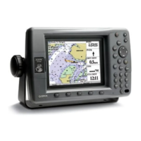
Full-featured plotters offer big pictures with exceptional display quality on 6-inch or 10-inch screens.

Display and Connectivity Options

Features configurable windows, 1 PC monitor output, and 2 video inputs for versatile monitoring.

Advanced Marine Network

Built-in high-speed marine network links displays and sensors for weather, radar, and sonar data.

Navigation and Moving Map Features

Waypoints, Routes, and Track Log

Supports 4000 waypoints, 50 reversible routes (300 points each), and a 10,000-point automatic track log.

Alarms and Tables

Includes various alarms (anchor drag, arrival) and built-in celestial/tide tables for US.

Map Datums and GPS Performance

Supports over 100 map datums and provides detailed GPS performance specs including accuracy.

Moving Map Basemap

Built-in worldwide marine basemap with coastlines, rivers, lakes, and political boundaries.

Data Cartridges

Utilizes user-programmable or preprogrammed data cards with detailed BlueChart™ marine cartography.

Plotting Scales and Physical Specs

Features push-button zoom control, power requirements, and physical dimensions for plotters.

Display Specifications

Details display size, resolution, colors, and backlighting for both 3006C and 3010C models.

Accessories and Compatibility

Lists standard and optional accessories, including remote controls and data cards.

Related product manuals