GPSMAP 640 Owner’s Manual 11
Marine Mode: Using Charts
Using BlueChart g2 Vision
Optional BlueChart g2 Vision preprogrammed SD cards allow you
to get the most out of your GPSMAP 640. In addition to detailed
marine charting, BlueChart g2 Vision has the following features:
Mariner’s Eye 3D
—provides a view from above and behind
the boat for a three-dimensional navigation aid. The BlueChart
g2 Vision Mariner’s Eye 3D is more detailed than the standard
Perspective 3D screen.
Fish Eye 3D
—provides an underwater, three-dimensional
view that visually represents the sea oor according to the
information on the chart.
Fishing Charts—displays the chart with enhanced bottom
contours and without navigational data. This chart works well
for offshore deep-sea shing.
High Resolution Satellite Imagery
—provides high-resolution
satellite images for a realistic view of the land and water on the
Navigation chart.
Detailed Roads and POI data
—displays roads, restaurants,
and other points of interest (POIs) along the shore.
Auto Guidance
—uses specied safe depth, safe height, and
chart data to suggest the best passage to your destination.
•
•
•
•
•
•
Using Mariner’s Eye 3D
When using a BlueChart g2 Vision SD card, you can view the
Mariner’s Eye 3D screen. The Mariner’s Eye 3D screen is similar
to the Perspective 3D screen (page 10), but renders a true 3D
screen. This view is helpful when navigating tricky shoals, reefs,
bridges, or channels, and is benecial when trying to identify entry
and exit routes in unfamiliar harbors or anchorages. Mariner’s Eye
3D provides a three-dimensional view of both the shore and the sea
oor.
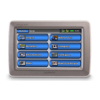
To access the Mariner’s Eye 3D screen from the Home screen,
touch Charts > Mariner’s Eye 3D.
As with the Perspective 3D screen, touch the button to move
the view closer to your boat and lower to the water. Touch the
button to move the view away from the boat. This is momentarily
indicated by the scale ( ) at the bottom of the screen.
Touch and drag the map to the left or the right to pan the 3D
perspective.