Do you have a question about the Magellan eXplorist 110 and is the answer not in the manual?
| Sport (fitness, running) | Yes |
|---|---|
| Marine (chartplotters, sounders) | No |
| Live service | - |
| Routes quantity | 25 |
| Tracks quantity | 10 |
| Number of waypoints | 500 |
| GPS accuracy - position | 5 m |
| Map coverage | World |
| Display diagonal | 2.2 \ |
| Display resolution | 240 x 320 pixels |
| Storage media type | Flash |
| Compatible memory cards | Not supported |
| Internal storage capacity | 2 GB |
| Processor model | SiRFStar III |
| Processor frequency | 233 MHz |
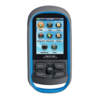
| Form factor | Handheld |
| Product color | Blue, Grey |
| International Protection (IP) code | IPX7 |
| USB 2.0 ports quantity | 1 |
| Battery type | AA |
| Power source type | Battery |
| Battery life (max) | 18 h |
| Battery technology | Alkaline |
| Number of batteries supported | 2 |
| Operating temperature (T-T) | -10 - 60 °C |
| Depth | 36 mm |
|---|---|
| Width | 56 mm |
| Height | 111 mm |
| Weight | 147 g |
Emphasizes not using the navigation device while driving a vehicle for safety.
Stresses good judgment, careful operation, and using only approved accessories for optimal performance.
Details FCC rules for digital devices, interference, and mandated compliance statements.
Covers FCC and IC radiation exposure limits and compliance requirements for safe operation.
Warns that unauthorized modifications can void user authority to operate the equipment.
Explains joystick use, installing, replacing, and setting battery types for the device.
Guides on turning the device on/off, using suspend mode, and conserving battery life.
Details backlight settings, dashboard access, main menu, and options menu for user interaction.
Explains the BACK button functionality and the on-screen keyboard for text input.
Details map modes, scale, data fields, zoom levels, and displaying the compass.
Explains active tracks, origin/destination lines, and route lines on the map.
Covers track hiding, clearing, starting, and creating backtrack routes.
Describes using pan mode to navigate the map and create waypoints at specific locations.
Guides on how to display and change between different dashboard screens.
Introduces specific dashboard screens like Compass, Satellite Status, and Altimeter.
Explains setting the number and type of data fields displayed on dashboard screens.
Covers accessing, sorting, searching, and editing saved waypoints for efficient management.
Details routing to waypoints, viewing on map, creating via panning, and projecting new waypoints.
Guides on how to save the device's current position as a new waypoint for future reference.
Overview of geocaching and installing the Magellan Communicator for data transfer.
Details uploading geocaches from geocaching.com using the 'Send to GPS' feature.
Explains installing geocaches via drag 'n drop and from the geocache detail page.
Covers accessing, sorting, filtering, and navigating geocaches from the list view.
Guides on adding new geocaches, recording field notes, and saving current locations as geocaches.
Guides on accessing the Tools Menu and its various utility functions.
Explains accessing receiver settings and viewing detailed statistics for the current active track.
Details time-related tools like fishing/hunting times, sun/moon times, and waypoint projection.
Covers accessing help files, product demos, screen capture, and setting owner information.
Guides on accessing the Settings Menu, adjusting brightness, volume, and power timers.
Covers selecting battery type and configuring date, time, calendar, and time zone settings.
Details map orientation, data fields, quick info, and line display settings for navigation.
Covers waypoint display styles, units of measure, and track logging modes.
Explains setting arrival and proximity alarms, and configuring night mode usage.
Details assigning joystick functions, compass graphics, and background images.
Covers GPS on/off, coordinate systems, navigation settings, and viewing satellite status.
Guides on memory tools, connectivity, diagnostics, language, and product information.
