Do you have a question about the Magellan RoadMate and is the answer not in the manual?
Maximum operating temperature for safe device use to prevent damage.
Details about the internal rechargeable battery and its servicing.
Proper procedures and precautions for charging the device using various adapters.
Instructions for turning the GPS device on and off, including suspend mode.
Procedures for monitoring battery charge and GPS signal strength indicators.
How to adjust audio volume from the map screen and settings menu.
Adjusting screen brightness and dimming options for battery saving.
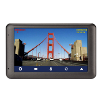
Explanation of the primary menu interface and its accessible icons.
Guidance on using the on-screen keyboard for data entry.
How the predictive city search feature works based on location.
Feature for efficient and error-free city and street name entry.
Step-by-step guide to connect a phone via Bluetooth for data transfer or calls.
Tips for choosing an optimal mounting position for the receiver for visibility.
How to properly connect the USB power cable to the device's cradle.
Instructions for securely mounting the car cradle using its suction cup.
How to physically connect the Magellan RoadMate receiver to its cradle.
Positioning the device for comfortable and safe viewing while driving.
Plugging the device's power adapter into the vehicle's power receptacle.
Advice on preventing theft by not leaving the device visible when unattended.
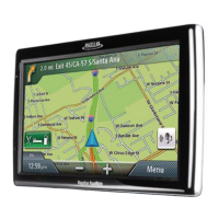
Display elements and information when the map is viewed without an active route.
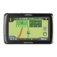
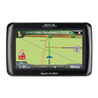
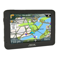
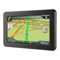
Display elements and information when the map is used for navigation.
Option to switch between 2D top-down and 3D perspective map views.
Creating a route by selecting a point directly on the map interface.
Displays current position, address, intersections, and coordinates.
How to save the current location into the device's address book.
Details of upcoming driving instructions and route steps for navigation.
How to adjust audio volume directly from the map screen interface.
Step-by-step guide to setting an address as a destination.
Setting a destination using intersecting streets to pinpoint a location.
Routing to the geographical center of a city when no specific address is known.
How to navigate to a previously visited location from the history list.
Adding past destinations from history into the device's address book.
How to find and view saved addresses within the address book.
Navigating to a saved address directly from the address book.
Adding new addresses manually or from Points of Interest.
Assigning favorite addresses to quick access buttons on the OneTouch menu.
Assigning POI searches to quick access buttons for frequent use.
Navigating to saved addresses or POIs using pre-assigned OneTouch buttons.
Finding and routing to Points of Interest based on predefined categories.
Finding and routing to Points of Interest by searching their specific name.
Finding commonly used Points of Interest located near highway exits.
Setting a primary destination for quick and easy access.
Navigating to the saved home address from the OneTouch menu.
Overview of map and maneuver list during active navigation.
Choosing how routes are calculated (e.g., fastest time, shortest distance).
Functions like cancelling a route or detouring to bypass issues.
How to find and select an alternate route to bypass traffic or closures.
Adding multiple stops or destinations to a single route.
Modifying an existing multi-destination route by reordering or removing stops.
Step-by-step guide to connect a phone via Bluetooth for the first time.
Accessing and configuring various Bluetooth options like auto-connect.
Transferring phone contacts to the device for easier calling.
Managing calls, volume, and microphone gain via Bluetooth connection.
How traffic delays are displayed on the map interface.
How to reroute the navigation to bypass traffic delays.
How to access and view the vehicle profile settings menu.
Entering vehicle height, width, and length for accurate routing.
Entering vehicle weight and type for optimized route calculations.
Specifying hazmat classification for routing purposes where applicable.
How to enter the main system settings menu for customization.
Adjusting screen brightness and dimming options for optimal viewing.
Setting display time format and local time zone for accurate timekeeping.
Customizing map appearance like night mode, heading, and POI visibility.
Setting default route methods and turn warning alerts.
Enabling and configuring live traffic information and warnings.
Setting GPS position and viewing current GPS status information.
Restoring the device to its original factory default settings.
Setting audible and visual speed limit alerts for safe driving.