Information Sources
The SN3308 will display data from some or all of the following
instruments:
■
NAV1 and NAV2 receivers
■
DME1 and DME2
■
LNAV1 and LNAV2 (GPS or loran)
■
Marker beacon receiver
■
Weather detection (WX-500 Stormscope
®
)
■
ADF1 and ADF2
■
Directional gyro and fluxgate
The following section of the manual describes the appearance of the
SN3308 display, and identifies each functional element. Detailed
descriptions of these elements and a tutorial guide to their use are
presented in later sections.
Appendix 2 of this manual contains fold-out pages with full-color
illustrations of SN3308 displays. You may want to fold these pages out
for reference while reading this manual.
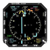
Display Areas
The
primary display
area shows either a 360-degree or a 70-degree
ARC view, as indicated by the white compass ring. The white airplane
represents the aircraft’s current position. The primary display area
may also depict the current GPS flight plan, airport, navaids,
intersections, airspace and/or Stormscope
®
data if the map feature
has been enabled. Several indicators (see below) are also presented
within the primary display area.
The
upper display
area presents data from the selected course
navigation instrument. The actual data displayed depends on the
navigation source (VOR/DME, GPS, or loran) but it will generally
include bearing, distance and ground-speed, if available. The upper
display area also includes information on the map status, WX-500
Stormscope
®
status (if installed), and an annunciation of whether the
VOR nav display is currently receiving either a localizer or a full ILS
(localizer/glideslope) signal.
2-1
2
Display Overview
CHAPTER