EasyManuals Logo

Apollo MX20 User Manual

Default Icon
35 pages
To Next Page IconTo Next Page
To Previous Page IconTo Previous Page
Page #23 background imageLoading...
Page #23 background image
Detailed
Operation
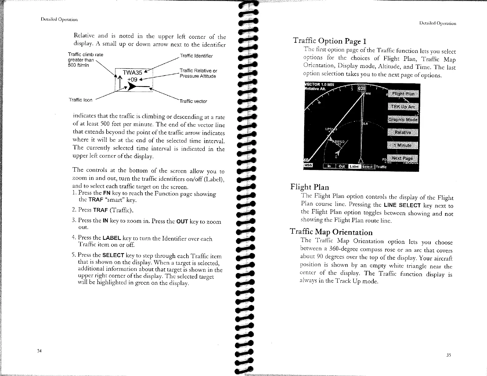
The
first
oprion
page
of rhe
Traffic
function
lets
you
select
options
for
the
choices
of
Flight
plan,
Traffic
Map
Orientation,
Display
mode,
Altitude,
and
Time.
The
last
option
selection
takes
you
to
the
next
page
of
options.
Traffic
Option
Page
I
üT
ê
ê
JF
JF
ê
dp
ep
JF
EF
JP
ep
-tÐ
ep
.F
ep
EF
ê
ê
ê
ê
ê
EF
ê
ê
jp
ê
ê
ê
d.
ê
ja
Dctailcd
Opcration
Relative
and
is
display.
A small
Trafüc
climb rate
greater
than
500 fr/min
noted
in
the upper
left
corner
of the
up
or
down
arrow
next
to the
identifier
Traffic
ldentifìer
Trafüc
Relative
or
Pressure
Altitude
Trafüc
lcon
indicates
that
the
traffic
is climbing
or descending
ar
a rare
of at
least
500
feet per
minute.
The
end
of the vector
line
that
extends
beyond
the point
of the
traffic
arrow
indicares
where
it
will
be
at
the end
of the
selected
time
interval.
The
currently
selected
time
interval
is indicated
in
the
upper
left
corner
of
the
display.
The
controls
ar
the
bottom
of the
screen
allow you
to
zoom
in and
out,
rurn
rhe
traffic
identifiers
onloff
(Label),
and
to select
each
traffic
target
on the
screen.
l. Pres:the_FN
key
to- reachìhe
Function
page
showing
the
TRAF
"smart"
key.
2. Press
TRAF
(Traffic).
3. Press
the lN
key
to zoom
in.
Press
the OUT
key to
zoom
out.
4.
Press
the LABEL
key
to turn
the Identifier
over each
Traffic
item
on
or
off,
5. Press
the
SELECT
key to
step through
each
TrafÍìc
item
that
is shown
on the
display.
When-a
target
is
selected,
additional
information
about
that
rargetîs
shown
in
tÉe
up..ggr
righ¡
corner-of
the
display.
Thãselected
target
will
be
highlighted
in
green
bn ìhe
display.
Flight
Plan
The
Flight
Plan
option
controls
the
display
of
the
Flight
Plan
course
line.
Pressing
the
LINE
SELECT
key
nexito
the
Flight
Plan
option
toggles
berween
showing
and
nor
showing
the
Flight
Plan
route
line.
Traffic
Map
Orienration
The
Traffic
Map
Orientation
option
lets
you
choose
berween
a
360-degree
compass
rose
or
an
arc
that
covers
about
90
degrees
over
rhe
top
ofthe
display.
your
aircraft
position
is
shown
by
an
empty
white
triangle
near
the
center
of
the
display.
The
Traffic
function
display
is
alw'ays
in
the
Track
Up
mode.
i5

Other manuals for Apollo MX20

Questions and Answers:

Question and Answer IconNeed help?

Do you have a question about the Apollo MX20 and is the answer not in the manual?

Apollo MX20 Specifications

General IconGeneral
BrandApollo
ModelMX20
CategoryMonitor
LanguageEnglish