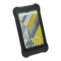
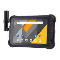
The CHCNAV LT800H is a high-end GNSS RTK tablet designed for mapping and geospatial applications, running on Android 12 OS. It is built to withstand harsh environments, featuring an IP67 dust and waterproof rating and the ability to survive a 1.2m drop onto concrete.
Function Description:
The LT800H serves as a robust and precise tool for surveying and mapping tasks. It integrates advanced GNSS RTK capabilities, allowing for highly accurate positioning. The tablet can connect to the internet via Wi-Fi or mobile network to access GNSS RTK Corrections Service providers. It supports various GNSS constellations including GPS, GLONASS, GALILEO, BDS, and QZSS, ensuring comprehensive satellite tracking for reliable data collection. The device is equipped with a camera for capturing images and videos, which can be useful for documentation and visual data integration in geospatial projects. It also features a range of sensors such as NFC, G-sensor, light sensor, E-compass, and gyroscope, enhancing its utility for diverse field applications. The LandStar 8 software, pre-installed on the tablet, facilitates project creation, coordinate system management, connection to GNSS modules, CORS/RTK network correction login, and survey operations including map survey and sky plot visualization.
Important Technical Specifications:
- Operating System: Android 12.0 GMS certified
- CPU: Advanced octa-core CPU 2.0 GHz
- RAM: 6 GB
- ROM: 128 GB (expandable up to 256 GB with Micro SD card)
- GNSS Constellations:
- BDS: B1I, B2I, B3I, B1C, B2a, B2b
- GPS: L1C/A, L1C, L2P (Y), L2C, L5
- GLONASS: L1, L2
- Galileo: E1, E5a, E5b, E6*
- QZSS: L1, L2, L5, L6*
- SBAS*: L1, L5
- RTK Accuracy: 2 cm HRMS
- SBAS Accuracy: < 1 m HRMS
- Channels: 1408
- Wi-Fi: IEEE 802.11a/b/g/n/ac
- Network 4G Modem:
- GSM: 850/900/1800/1900
- WCDMA: B1/B2/B4/B5/B8/B19
- CDMA EVDO: BC0
- TD-SCDMA: B34/B39
- LTE-FDD: B1/B2/B3/B4/B5/B7/B8/B12/B17/B18/B19/B20/B26/B28
- LTE-TDD: B34/B38/B34/B39/B40/B41
- Bluetooth: Bluetooth™ 5.1
- USB: Type C/OTG
- Li-ion Battery: 9000mAh, 3.8V
- Battery Life: 8 hours
- Charging Time: 4.0 hours (Fast charging: QC 3.0)
- Front Camera: 8 megapixels
- Back Camera: 16 megapixels (Integrated flashlight)
- Display: 8.1" capacitive multi-touch IPS screen with 5 points, 1920 x 1200 resolution, 600 cd/m² brightness, Corning® Gorilla® Glass 3, and mapping pen support.
- Physical Durability: IP67 dustproof and waterproof, survives 1.2m drop onto concrete.
- Humidity: 5% - 95% RH (without condensation)
- Dimensions (L x W x H): 215.5 mm x 130 mm x 14.5 mm (8.5 in x 5.1 in x 0.6 in)
- Weight: 600 g (19.4 oz)
- Operating Temperature: -20 °C to +60 °C (-4°F to +140°F)
- Storage Temperature: -40 °C to +70 °C (-40°F to +158°F)
- Sensors: NFC, G-sensor, Light sensor, E-compass, Gyroscope.
Usage Features:
- Power On/Off: Long press the power button for 3-5 seconds to turn on the device.
- SIM Card & MicroSD Card Installation: Slots are available for SIM cards (SIM 1, SIM 2) and a MicroSD card for expanded storage.
- Language & Input Settings: Users can select their preferred language and manage input settings through the system menu.
- Date & Time Settings: Manual or automatic date and time configuration, including time zone and 24-hour format options.
- Display Customization: Adjust brightness level, screen timeout, font size, and enable dark theme.
- Wi-Fi Connectivity: Connect to available Wi-Fi networks by selecting the network and entering the password.
- Bluetooth Pairing: Discover and pair with nearby Bluetooth devices.
- USB Connection: Connect to a PC via USB Type-C for charging and data transfer, allowing access to the tablet's storage space.
- Camera Functionality: Use the integrated front and back cameras for photos and videos, with options for panorama mode and camera settings.
- 4G Connectivity: Insert a SIM card, select the preferred network type, and enable mobile data for internet access.
- Location Services: Enable location services for GNSS positioning.
- IMEI Number Check: Easily check the device's IMEI numbers by dialing '*#06#'.
- LandStar 8 Software:
- Project Management: Create new projects, define coordinate systems (user-defined or pre-defined), and manage project settings.
- GNSS Module Connection: Connect to the LT800H GNSS module by selecting "Android location" as the type and "LT800H" as the model.
- CORS/RTK Network Correction: Configure NTRIP settings to log in to correction networks, including server details, mount point, username, and password.
- Survey Operations: Perform map surveys and visualize satellite tracking with the Sky Plot feature, which displays the number of satellites from various constellations being tracked.
- Real-time Kinematic (RTK) Status: The software indicates RTK status (RTD, Float, or Fix) to show the quality of GNSS correction data.
Maintenance Features:
- Charging: Charge the internal rechargeable lithium-ion battery using the provided USB cable and power adapter. It is crucial to follow charging instructions and use authorized equipment to prevent damage.
- Care: Handle the LT800H with appropriate care as it is high-precision electronic equipment, despite its rugged design.
- Software Updates: The device's software and firmware can be updated to ensure optimal performance and access to new features.
- Troubleshooting: Technical assistance is available through local distributors or CHCNAV's technical support via their website or e-mail.
- Warranty: Unauthorized disassembly or modification of the device will void the warranty.