6.1Initialtest
Oncetheunitisfullyconnectedandinstalled,performaninitialpowerontesttoverifycorrectoperation.
Producttype
Unittouseforverifying
operation
Application(s)tousefor
verifyingoperationExamplescreen
MFD
Chartapplication(checkthe
vesselpositiondisplayedon
thechartagainstyouractual
proximitytoaknowncharted
object).
Instrumentorpilotcontrol
head
Checkthatapositionxis
displayed.
GNSSReceiver
VHFradio
Checkthatapositionxis
displayed.
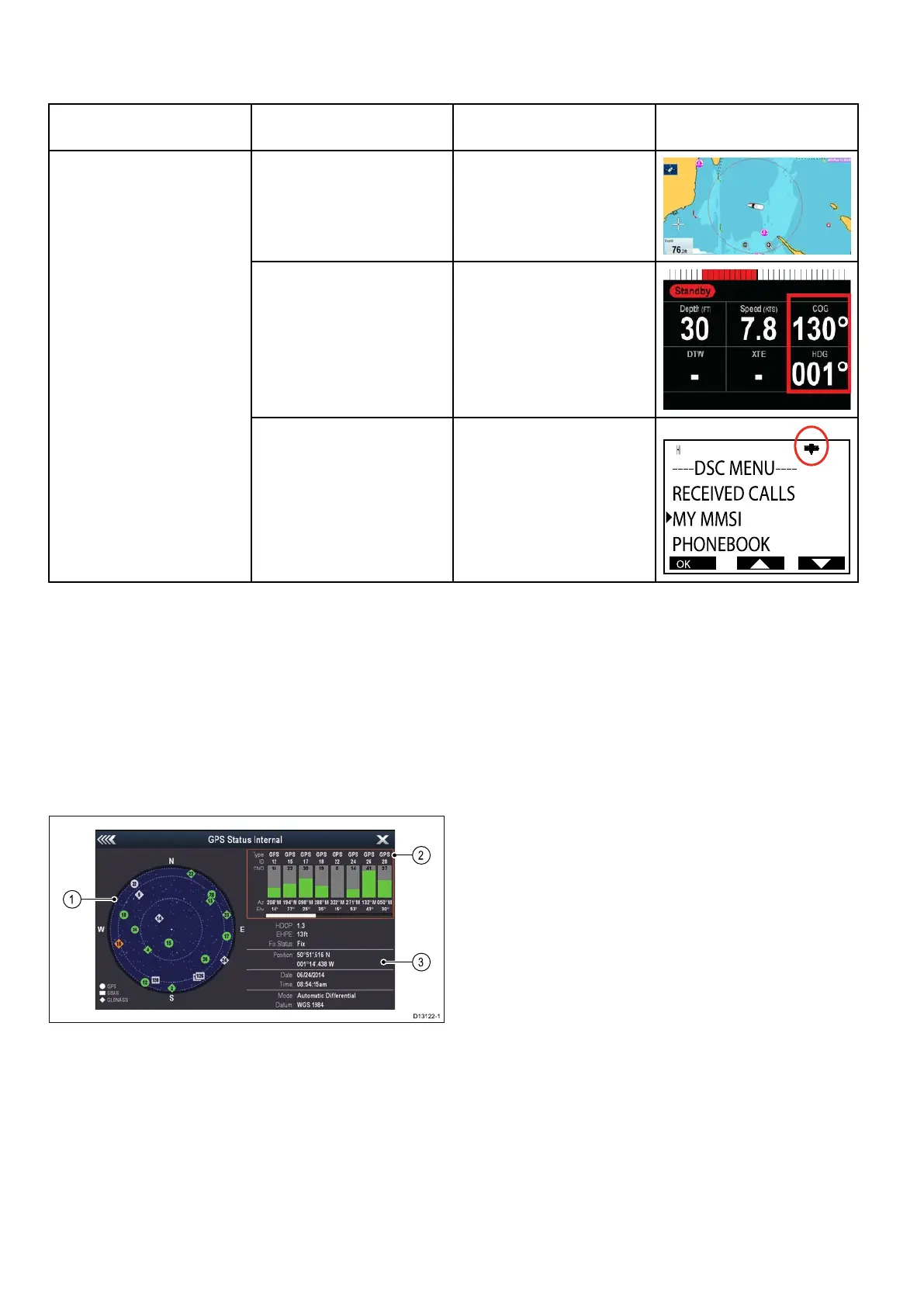
GPSStatus
ProductswithaninternalGPSreceiverorGNSS
(GPS/GLONASS)receivercanusetheGPSstatus
pagetoviewthestatusoftheavailablecompatible
satellites.
Thesatelliteconstellationsareusedtopositionyour
boatintheChartapplication.Youcansetupyour
receiverandcheckitsstatusfromthemenu.For
eachsatellite,thescreenprovidesthefollowing
information:
1.Skyview
2.Satellitestatus
3.Positionandxinformation
Skyview
Skyviewisavisualrepresentationthatshows
thepositionofnavigationsatellitesandtheirtype.
Satellitetypesare:
•Circle—Acircleidentiesasatellitefromthe
GPSconstellation.
•Square—Asquareidentiesan(SBAS)
differentialsatellite.
•Diamond—Adiamondidentiesasatellitefrom
theGLONASSconstellation.
Satellitestatusarea
TheSatellitestatusareadisplaysthefollowing
informationabouteachsatellite:
•Type—Identieswhichconstellationthesatellite
belongsto.
•ID—Displaysthesatellitesidenticationnumber.
•CNO(Carrier-to-noiseratio)—Displaysthesignal
strengthofeachsatelliteshownintheSkyview:
–Grey=searchingforsatellite
–Green=satelliteinuse
–Orange=trackingsatellite
•AzimuthandElevation—Providestheangleof
elevationandazimuthbetweenthelocationofthe
receiverandthesatellite.
Positionandxinformation
Thefollowingpositionalandxinformationis
provided:
•HorizontalDilutionofPrecision(HDOP)
—HDOPisameasureofsatellitenavigation
accuracy,calculatedfromanumberoffactors
includingsatellitegeometry,systemerrorsin
thedatatransmissionandsystemerrorsinthe
receiver.Ahigherguresigniesagreater
positionalerror.Atypicalreceiverhasanaccuracy
ofbetween5and15m.Asanexample,assuming
areceivererrorof5m,anHDOPof2would
representanerrorofapproximately15m.Please
rememberthatevenaverylowHDOPgureis
NOguaranteethatyourreceiverisprovidingan
Chapter 6: System checks and troubleshooting

 Loading...