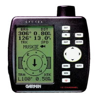
Satellite Page
The GPS 126/128’s Satellite Page displays the status
of various receiver functions. The status information
will help you understand what the GPS 126/128 is
doing at any given time, and will tell you whether or
not the receiver has calculated a position fix.
Sky View and Signal Strength Bars
The sky view and signal strength bars give you an
indication of what satellites are visible to the receiver,
whether or not they are being used to calculate a posi-
tion fix, and the signal quality. The satellite sky view
shows a bird’s-eye view of the position of each available
satellite relative to the unit’s last known position. The
outer circle represents the horizon (north or track up);
the inner circle 45º above the horizon; and the center
point directly overhead. You can use the sky view to
help determine if any satellites are being blocked, and
whether you have a current position fix (indicated by a
‘2D NAV’ or ‘3D NAV’ in the status field). You can also
set the sky view to a track-up configuration by changing
the “orientation” option on the Map Page. (See pg. 41
for Map Setup instructions.)
When the receiver is looking for a particular satel-
lite, the corresponding signal strength bar will be blank
and the sky view indicator will be highlighted. Once the
receiver has found the satellite, a hollow signal strength
bar will appear, indicating that the satellite has been
found and the receiver is collecting data from it. The
satellite number in the sky view will no longer appear
highlighted. As soon as the GPS 126/128 has collected
the necessary data to calculate a fix, the status field will
indicate a 2D or 3D status.
Satellite Page
REFERENCE
14
The GPS 126/128’s
Satellite Page will help
you determine which
satellites are in view, and
whether or not any satel-
lites are being “shaded”
or blocked. (See satellites
07 and 19 above).
By periodically monitor-
ing the signal strength
bars at the bottom of the
page and the north up
sky view, you will be able
to see how moving to
another area with a
clearer view of the sky
will improve satellite
reception and speed up
signal acquisition.
Horizontal
Accuracy
Signal Strength
Indicators
Skyview
Display
Status
Field
126/128 Manual (new) 6/15/98 9:51 AM Page 14