Do you have a question about the Garmin 480 and is the answer not in the manual?
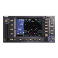
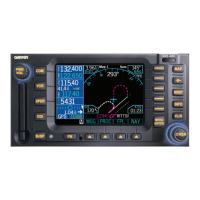
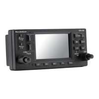
Explains controls on the left side of the unit.
Explains controls on the right side of the unit.
Describes the function of the unlabeled keys below the display.
Explains the function of the menu item smart keys.
Details the startup sequence and power-up procedure.
Explains how the system verifies database integrity and expiration.
Indicates which field is currently selected for data entry.
Shows where the currently active function is displayed.
Describes how menu labels correspond to smart keys.
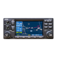
Explains the map display and its features.
Symbol indicating a waypoint in the flight plan.
Symbol representing an intersection waypoint.
Symbol for the user's aircraft (single-engine).
Displays different COM related pages.
Displays different Moving Map pages.
Displays different Direct-To function pages.
Displays nearest waypoints by type.
Displays XPDR related pages.
Displays airport and waypoint information pages.
Displays NAV radio and test log pages.
Displays parallel track information.
Accessing and using the system timers.
How traffic information is displayed on the map.
Accessing the traffic display menu.
Controls and functions for the communication radio.
Controls and functions for the navigation radio.
Highlights waypoints in the active flight plan for actions.
Selects waypoints from the database.
Activates direct course to the selected waypoint.
Activates guidance to a specific leg of the flight plan.
Adds an intercept course to a selected waypoint.
Navigates from a waypoint on a selected course.
Sets an intercept course using CDI/HSI control.
Navigates directly to a waypoint in the active flight plan.
Navigates directly to a waypoint not in the active flight plan.
How to reference the map to True North.
Customizes Nav information displayed in Map Mode.
Activates and uses the map panning feature.
Adjusts the map range for zooming in or out.
Steps to create a new user-defined waypoint.
Managing up to 500 user-defined waypoints.
Steps to create or edit a user waypoint.
How to search for a user-defined waypoint.
Accessing and navigating system mode functions.
Displays GPS status, time, and satellite information.
Shows unit serial and software versions.
Configures system settings for the aircraft.
Sets limits for displaying nearest airports.
Transfers frequencies to active or standby radio.
How to view detailed information about a selected waypoint.
Create and use up to eight custom checklists.
Steps to create or edit a checklist.
How to follow a checklist during operation.
Reorders the position of checklists.
View new or old system messages.
Steps to create a new flight plan with origin and destination.
Selects and makes a saved flight plan active.
Removes the currently active flight plan.
Modifies origin, destination, or alternate waypoints.
Adds waypoints or airways to an existing flight plan.
Removes waypoints or airways from a flight plan.
Provides a track-based Horizontal Situation Indicator (HSI) view.
Associates procedures with departure or destination airports.
Predicts GPS coverage for waypoints.
Guides the aircraft through the missed approach sequence.
Provides vectors for final approach in the terminal area.
Controls remote transponder functions.
Modifies the transponder ident and squawk code.
Displays traffic relative to the aircraft's reported position.
Displays a small window for traffic advisories.
Rings showing relative distances on the traffic display.
Explains symbols used for traffic advisories.